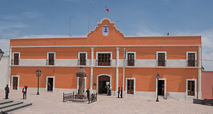
Zempoala | |
|---|---|
Municipality and town | |
 | |
| Coordinates: 19°54′55″N 98°40′08″W / 19.91528°N 98.66889°W | |
| Country | |
| State | Hidalgo |
| Municipal seat | Zempoala |
| Area | |
| • Total | 305.8 km2 (118.1 sq mi) |
| Population (2020) | |
| • Total | 57,906 |
| Time zone | UTC-6 (Central) |
Zempoala is a town and one of the 84 municipalities of Hidalgo, in central-eastern Mexico. The municipality covers an area of 319.78 km².[1] The name Zempoala derives from the Nahuatl roots "Cempoalli", meaning "twenty" and "tlan", meaning "place"; giving Zempoala the meaning of "place of twenties", referring to the market held every twenty days.[1]
As of 2020, the municipality had a total population of 57,906.[2]
- ^ a b "Hidalgo - Zempoala". www.inafed.gob.mx. Retrieved 2021-05-25.
- ^ "Zempoala (Municipality, Mexico) - Population Statistics, Charts, Map and Location". www.citypopulation.de. Retrieved 2022-02-25.

