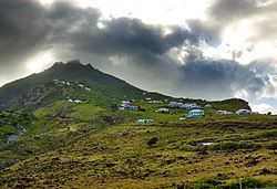
Zion's Hill | |
|---|---|
 Hell's Gate | |
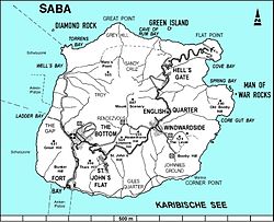
 Map of Saba showing Zion's Hill | |
| Coordinates: 17°38′35″N 63°13′37″W / 17.64306°N 63.22694°W | |
| Country | |
| Public body | |
| Elevation | 300 / 450 m (1,000 / 1,480 ft) |
| Population (2001)[1] | |
| • Total | 283 |
| Time zone | UTC-4 (AST) |
| Climate | Aw |
Zion's Hill, also known by its former name Hell's Gate, is a town on the Dutch Caribbean island of Saba.[2] Locally, it is divided into Upper Hell's Gate and Lower Hell's Gate.
Upper Hell's Gate is the highest village in the Kingdom of the Netherlands, at an altitude of 450 m (1,480 ft) above sea level. Lower Hell's Gate is located approximately 300 m (980 ft) above sea level. On some maps, Lower Hell's Gate includes Flat Point, location of the Juancho E. Yrausquin Airport and the Flat Point Tide Pools.
- ^ "Geodata 2001, Saba & Sint.Eustatius, Census 2001". Centraal Bureau voor de Statistiek, Netherlands Antilles. 2001. p. 17. Retrieved 3 May 2021.
- ^ The villages of Saba (Saba Tourist Bureau)