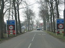
Zoeterwoude-Dorp | |
|---|---|
Town | |
 Eastern entrance to Zoeterwoude-Dorp, from the Nieuwe Weg | |
 | |
 The town centre (red) and the statistical district (light green) of Zoeterwoude-Dorp in the municipality of Zoeterwoude. | |
| Coordinates: 52°7′9″N 4°29′48″E / 52.11917°N 4.49667°E | |
| Country | Netherlands |
| Province | South Holland |
| Municipality | Zoeterwoude |
| Area | |
| • Total | 119 ha (294 acres) |
| • Water | 3 ha (7 acres) |
| Population (2015) | |
| • Total | 4,205 |
| • Density | 3,500/km2 (9,200/sq mi) |
| Time zone | UTC+1 (CET) |
| • Summer (DST) | UTC+2 (CEST) |
| Postal code | 2381 |
| Dialing code | 071 580 |
| [1][2][3] | |
Zoeterwoude-Dorp is a town in the Dutch province of South Holland. It is a part of the municipality of Zoeterwoude, and lies about 3.5 km south of Leiden.[4][5] It has its origins in the 13th century, and even though the whole town went up in flames in the late 16th century, it was rebuilt within a hundred years and significantly expanded over the course of the 20th century.
- ^ "Wetenswaardigheden, cijfers en statistieken over over de buurt Zoeterwoude-Dorp in Zoeterwoude". RTL Nieuws (in Dutch). RTL Group. Retrieved 10 March 2016.
- ^ "Kerncijfers wijken en buurten 2015". CBS (in Dutch). 30 November 2015. Retrieved 10 March 2016.
- ^ "2381 is de postcode van de plaats Zoeterwoude". Postcode Adresboek (in Dutch). Wux. Retrieved 10 March 2016.
- ^ "Over Zoeterwoude". Municipality of Zoeterwoude (in Dutch). Retrieved 10 March 2016.
- ^ ACME Mapper (Map). Cartography by Google Maps. ACME Laboratories. Retrieved 10 February 2016.