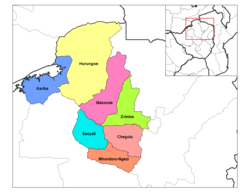
Zvimba District | |
|---|---|
 Zvimba District (light green) in Mashonaland West Province | |
| Coordinates: 17°42′S 30°12′E / 17.700°S 30.200°E | |
| Country | Zimbabwe |
| Province | Mashonaland West |
| Area | |
| • Total | 6,072 km2 (2,344 sq mi) |
| Population (2022 census) | |
| • Total | 348,002 |
| • Density | 57/km2 (150/sq mi) |
Zvimba District is a district of Mashonaland West Province, Zimbabwe.[1]
- ^ "Zvimba (District, Zimbabwe) - Population Statistics, Charts, Map and Location". www.citypopulation.de. Retrieved 17 February 2024.