| Djebel Uweinat | |
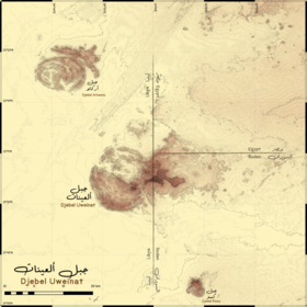
 Carte topographique du djebel Uweinat (au centre). | |
| Géographie | |
|---|---|
| Altitude | 1 934 m |
| Administration | |
| Pays | |
| Gouvernorat Chabiyat Wilayat |
Nouvelle-Vallée Al-Koufrah Nord |
| Géologie | |
| Roches | Granite, grès |
| modifier |
|
Le djebel Uweinat (en arabe جبل العوينات, gabal al-ʿuwaināt, littéralement « montagne des sources », aussi orthographié Al Awaynat, Auenat, Ouenat, Ouinat, Owainat, Oweinat, Uwaynat, Uweinat, Uwenat, Uweynat) est un massif montagneux à la frontière entre l'Égypte, la Libye et le Soudan.