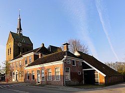
't Zandt | |
|---|---|
 't Zandt in 2011 | |
Location of 't Zandt in the province of Groningen | |
| Coordinates: 53°21′57″N 6°46′28″E / 53.36583°N 6.77444°E | |
| Country | Netherlands |
| Province | Groningen |
| Municipality | Eemsdelta |
| Area | |
• Total | 33.74 km2 (13.03 sq mi) |
| Elevation | 1.1 m (3.6 ft) |
| Population (2021)[1] | |
• Total | 970 |
| • Density | 29/km2 (74/sq mi) |
| Postal code | 9915[1] |
| Dialing code | 0596 |
't Zandt (Dutch pronunciation: [ət ˈsɑnt]; Gronings: t Zaand [ˈtsaːnt]) is a village in the Dutch province of Groningen. It is located in the municipality of Eemsdelta.
't Zandt was a separate municipality until 1990, when it was merged with Loppersum.[3] The municipality covered the villages 't Zandt, Zeerijp, Leermens, Eenum and Oosterwijwerd, and the hamlets Zijldijk, Kolhol, Korendijk and 't Zandstervoorwerk.[4]
- ^ a b c "Kerncijfers wijken en buurten 2021". Central Bureau of Statistics. Retrieved 8 April 2022.
two entries
- ^ "Postcodetool for 9915PA". Actueel Hoogtebestand Nederland (in Dutch). Het Waterschapshuis. Retrieved 8 April 2022.
- ^ Ad van der Meer and Onno Boonstra, Repertorium van Nederlandse gemeenten, KNAW, 2011.
- ^ Abraham Jacob van der Aa, "Aardrijkskundig woordenboek der Nederlanden", vol. 1 (A), 1839.

