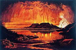
| 1886 eruption of Mount Tarawera | |
|---|---|
 Mount Tarawera in Eruption by Charles Blomfield | |
| Volcano | Mount Tarawera |
| Start date | 10 June 1886 |
| Start time | 2:00 a.m. |
| End date | 10 June 1886 |
| End time | 8:00 a.m. |
| Type | Plinian,[1] Peléan[citation needed] |
| Location | North Island, New Zealand 38°13′30″S 176°30′36″E / 38.22500°S 176.51000°E |
| VEI | 5 |
| Impact | c. 120 killed,[2] Pink and White Terraces destroyed, formation of Waimangu Volcanic Rift Valley, enlargement of Lake Rotomahana |
The 1886 eruption of Mount Tarawera was a violent volcanic eruption that occurred in the early hours of 10 June 1886 at Mount Tarawera, near Rotorua on New Zealand's North Island. The eruption reached an estimated volcanic explosivity index (VEI) of 5 and killed an estimated 120 people, making it the largest and deadliest in New Zealand during the past 500 years, a period that includes the entirety of European history in New Zealand.
The eruption began at roughly 2:00 a.m. and lasted for approximately six hours, causing a 10-kilometre-high (6.2 mi) ash column, earthquakes, lightning, and explosions heard as far away as Blenheim in the South Island – more than 500 kilometres (310 mi) away. A 17 kilometres (11 mi) long rift formed across the mountain and surrounding area during the eruption, starting from the Wahanga peak at the mountain's northern end and extending in a southwesterly direction, through Lake Rotomahana and forming the Waimangu Volcanic Rift Valley. This rift is where the basaltic dyke that fed the eruption reached the surface.
Damage in the local area was extensive, with ashfall blanketing nearby villages, including Te Wairoa. The eruption is responsible for the presumed destruction of the famed Pink and White Terraces, which prior to the eruption were New Zealand's most famous tourist attraction and brought visitors from across the British Empire. Lake Rotomahana, the former site of the terraces, significantly expanded as a result of the eruption as it filled portions of the newly formed rift valley.
- ^ Cite error: The named reference
SableEtAlwas invoked but never defined (see the help page). - ^ Cite error: The named reference
nzhistorywas invoked but never defined (see the help page). - ^ Seebeck, H.; Nicol, A.; Villamor, P.; Ristau, J.; Pettinga, J. (2014). "Structure and kinematics of the Taupo Rift, New Zealand". Tectonics. 33 (6): 1178–1199. Bibcode:2014Tecto..33.1178S. doi:10.1002/2014TC003569. ISSN 0278-7407. S2CID 129430650. Archived from the original on 15 September 2023. Retrieved 15 April 2023.
