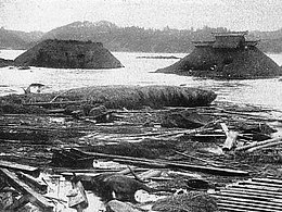
 Devastation caused by the tsunami at Sanriku. | |
| Local date | June 15, 1896 |
|---|---|
| Local time | 19:32:30 JST (UTC+09:00) |
| Magnitude | 8.5 Mw, 7.2 Ms[1][2] |
| Depth | Shallow |
| Epicenter | 39°30′N 144°00′E / 39.5°N 144.0°E |
| Type | Megathrust |
| Areas affected | Empire of Japan, United States |
| Total damage | Tsunami |
| Tsunami | Up to 38.2 m (125 ft) in Ryori, Kesen, Iwate, Tōhoku |
| Casualties | 22,066 people dead or missing[3] |
The 1896 Sanriku earthquake (明治三陸地震, Meiji Sanriku Jishin) was one of the most destructive seismic events in Japanese history.[3] The 8.5 magnitude earthquake occurred at 19:32 (local time) on June 15, 1896, approximately 166 kilometres (103 mi) off the coast of Iwate Prefecture, Honshu. It resulted in two tsunami waves which destroyed about 9,000 homes and caused at least 22,000 deaths.[4] The waves reached a then-record height of 38.2 metres (125 ft); this would remain the highest on record until waves from the 2011 Tōhoku earthquake exceeded that height by more than 2 metres (6 ft 7 in).[5]
From the tsunami records the estimated tsunami's magnitude is (Mt = 8.2),[6] much greater than expected for the seismic magnitude estimated from the observed seismic intensity (Ms=7.2).[2] This earthquake is now regarded as being part of a distinct class of seismic events, the tsunami earthquake.[7]
- ^ Nishimura, T.; Miura S.; Tachibana K.; Hashimoto K.; Sato T.; Hori S.; Murakami E.; Kono T.; Nid K.; Mishina M.; Hirasawa T. & Miyazaki S. (2000). "Distribution of seismic coupling on the subducting plate boundary in northeastern Japan inferred from GPS observations". Tectonophysics. 323 (3–4): 217–238. Bibcode:2000Tectp.323..217N. doi:10.1016/S0040-1951(00)00108-6.
- ^ a b Cite error: The named reference
Taniokawas invoked but never defined (see the help page). - ^ a b Cite error: The named reference
Nakaowas invoked but never defined (see the help page). - ^ Cite error: The named reference
USGSwas invoked but never defined (see the help page). - ^ "March 11th tsunami a record 40.5 metres high NHK". .nhk.or.jp. 13 August 2011. Archived from the original on 28 July 2011. Retrieved 15 June 2018.
- ^ Abe, K. (1981). "Physical size of tsunamigenic earthquakes of the northwestern Pacific". Phys. Earth Planet. Inter. 27 (3): 194–205. Bibcode:1981PEPI...27..194A. doi:10.1016/0031-9201(81)90016-9.
- ^ Kanamori, H. (1972). "Mechanism of tsunami earthquakes" (PDF). Phys. Earth Planet. Inter. 6 (5): 346–359. Bibcode:1972PEPI....6..346K. doi:10.1016/0031-9201(72)90058-1. Archived from the original (PDF) on 2011-06-14.
