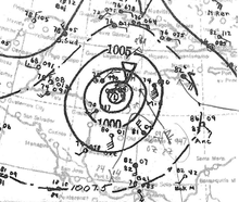
|name=. Remove this parameter; the article title is used as the name by default. Surface weather analysis of the hurricane at its peak intensity on November 8, southwest of Cuba | |
| Meteorological history | |
|---|---|
| Formed | October 30, 1932 |
| Dissipated | November 14, 1932 |
| Category 5 major hurricane | |
| 1-minute sustained (SSHWS/NWS) | |
| Highest winds | 175 mph (280 km/h) |
| Lowest pressure | ≤915 mbar (hPa); ≤27.02 inHg |
| Overall effects | |
| Fatalities | 3,103+ (Deadliest in Cuban history) |
| Damage | $40 million (1932 USD) |
| Areas affected |
|
| IBTrACS | |
Part of the 1932 Atlantic hurricane season | |
The 1932 Cuba hurricane, known also as the Hurricane of Santa Cruz del Sur[1] or the 1932 Camagüey hurricane,[2] was the deadliest and one of the most intense tropical cyclones on record to have made landfall in Cuba. It is the only Category 5 Atlantic hurricane ever recorded in November. The cyclone had a path through the Caribbean Sea atypical to most hurricanes developing late in the Atlantic hurricane season. The storm's strong winds, storm surge, and rain devastated an extensive portion of central and eastern Cuba, where the storm was considered the worst natural disaster of the 20th century. Though the effects from the hurricane were concentrated primarily on Cuba, significant effects were also felt in the Cayman Islands and the Bahamas, with lesser effects felt elsewhere.
The tropical depression that would later develop into the destructive hurricane was first located east of the Lesser Antilles on October 30, and tracked westward into the Caribbean Sea, reaching tropical storm strength the next day. Moving southwestward towards the southern portion of the Caribbean, the storm reached hurricane strength on November 2 before a period of rapid intensification ensued. On November 6, the tropical cyclone reached its peak intensity as a Category 5 hurricane with maximum sustained winds of 175 mph (280 km/h). The storm weakened to Category 4 intensity while recurving northeast, moving ashore Cuba's Camagüey Province on November 9 with winds of 150 mph (240 km/h). After traversing the island, the storm gradually weakened as it crossed the central Bahamas Islands and near Bermuda. On November 13, the system transitioned into an extratropical cyclone and dissipated the next day.
As an intensifying hurricane in the southern Caribbean Sea, the storm moved near the Netherlands Antilles and Colombia, causing widespread effects. A prolonged passage of Curacao resulted in the damaging of the harbor fortification. The storm lashed the coast of Colombia with strong winds and torrential rainfall, severely hampering the banana crop in the region and disrupting telecommunications. Several towns, particularly those near the coast, sustained significant infrastructural damage. Marked, albeit localized, damage to banana crops was also reported in Jamaica, where strong winds toppled numerous trees. In open waters, the storm's track brought it across numerous shipping lanes, largely disrupting shipping primarily in the central Caribbean and damaging several ships.