 The Sorlie Bridge connecting Grand Forks and East Grand Forks became submerged on April 17 | |
| Date | April 1997 |
|---|---|
| Location | Fargo–Moorhead -Fargo, ND -Moorhead, MN Greater Grand Forks -Grand Forks, ND -East Grand Forks, MN |
| Deaths | 0 |
| Property damage | $3.5 billion[1] |
| Part of a series on the |
| Red River of the North |
|---|
 |
| Major Floods |
| Geology |
| Infrastructure |
| Related Topics |
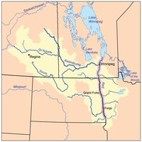
The Red River flood of 1997 in the United States was a major flood that occurred in April 1997, along the Red River of the North in North Dakota and Minnesota. The flood reached throughout the Red River Valley, affecting the cities of Fargo, Moorhead, and Winnipeg, while Grand Forks and East Grand Forks received the most damage, where floodwaters reached over 3 miles (5 km) inland, inundating virtually everything in the twin communities. Total damages for the Red River region were US$3.5 billion.
The flood was the result of abundant snowfall and extreme temperatures. Although river levels in Fargo reached record heights, the city was protected by several dikes and received minimal damage. In Grand Forks, however, the river crested at 54 feet (16 m), surpassing the 49-foot (15 m) estimate of flooding set by the National Weather Service. Within East Grand Forks, all but eight homes were damaged by floodwaters. Grand Forks mayor Pat Owens had to order the evacuation of over 50,000 people as a large portion of the city would eventually be flooded. A large fire started in Grand Forks, engulfing eleven buildings and sixty apartment units before being extinguished.
Those affected by the flood received donations from across the nation, along with billions in federal aid. City officials and flood-forecasters were criticized for the difference in estimates and actual flood levels. Fargo, Grand Forks, and East Grand Forks built new dikes to prevent damage from future floods and the Greater Grand Forks area began to rebuild around the river, developing a campground recreation area, park, and shopping districts where homes once stood.