 Buildings after the earthquake | |
| UTC time | 2001-01-26 03:16:40 |
|---|---|
| ISC event | 1763683 |
| USGS-ANSS | ComCat |
| Local date | 26 January 2001 |
| Local time | 08:46 am IST |
| Duration | 90 seconds |
| Magnitude | 7.6 Mw |
| Depth | 17.4 kilometres (10.8 mi) |
| Epicenter | 23°23′17″N 70°19′34″E / 23.388°N 70.326°E[1] |
| Type | Oblique-slip, Intraplate |
| Areas affected | India, Pakistan |
| Max. intensity | MMI X (Extreme) |
| Casualties | 20,023 fatalities, 166,951 injuries |
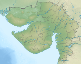
The 2001 Gujarat earthquake, also known as the Bhuj earthquake, occurred on 26 January at 08:46 am IST. The epicentre was about 9 km south-southwest of the village of Chobari in Bhachau Taluka of Kutch (Kachchh) District of Gujarat, India.[2][3]
The intraplate earthquake measured 7.6 on the moment magnitude scale and occurred at 17.4 km (10.8 mi) depth.[1] It had a maximum felt intensity of X (Extreme) on the Mercalli intensity scale. The earthquake killed at least 20,023 people (including 19 in southeastern Pakistan), injured another 166,000 and destroyed nearly over 400,000 buildings.[4][5][6]
- ^ a b ISC-GEM Global Instrumental Earthquake Catalogue (1900–2009), Version 9.1, International Seismological Centre, 27 June 2022
- ^ Gupta, Harsh K., et al. "Bhuj earthquake of 26 January 2001." Journal-Geological Society of India 57.3 (2001): 275–278.
- ^ "15 years of Gujarat earthquake: A trauma etched in Gujarat's memory". The Times of India. Retrieved 19 May 2017.
- ^ Cite error: The named reference
APR2001UPDATEwas invoked but never defined (see the help page). - ^ "Preliminary Earthquake Report". USGS Earthquake Hazards Program. Archived from the original on 20 November 2007. Retrieved 21 November 2007.
- ^ Sen, Kavita (January 2001). "Economic consequences of the Gujarat earthquake". Academia.


