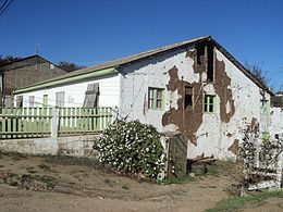
 Above: House damaged by the Pichilemu earthquakes, in the epicentre town, as seen on 16 April 2011. Below: Shakemap for the first of the Pichilemu earthquakes produced by the United States Geological Survey | |
 | |
| UTC time | 2010-03-11 14:39:43 |
|---|---|
| 2010-03-11 14:55:27 | |
| ISC event | 14554049 |
| 14400686 | |
| USGS-ANSS | ComCat |
| ComCat | |
| Local date | 11 March 2010 |
| Local time | 11:39 UTC-3 |
| 11:55 UTC-3 | |
| Magnitude | 6.9 Mw[1][2] |
| 7.0 Mw | |
| Depth | 33.1 kilometres (20.6 mi)[2] |
| 31.0 kilometres (19.3 mi)[3] | |
| Epicenter | Pichilemu, Chile 34°18′04″S 72°07′48″W / 34.301°S 72.13°W[2] |
| Areas affected | Chile Argentina |
| Max. intensity | MMI X (Extreme)[4] |
| Peak acceleration | 0.086 g (Curicó, Maule)[5] |
| Tsunami | Yes |
| Casualties | 1 dead |
The 2010 Pichilemu earthquakes (Spanish: Terremoto de Pichilemu de 2010), also known as the Libertador O'Higgins earthquakes, were a pair of intraplate earthquakes measuring 6.9 and 7.0 Mw that struck Chile's O'Higgins Region on 11 March 2010 about 16 minutes apart. The earthquakes were centred 15 kilometres (9.3 mi) northwest of the city of Pichilemu.[2]
The earthquakes were caused by increased regional stress arising from an earthquake on 27 February, centered offshore Maule Region, which was felt throughout central Chile. The Hawaii-based Pacific Tsunami Warning Center pointed out the possibility of local tsunamis within 100 kilometres (62 mi) of the epicentre, although small, but violent waves were seen in the Pichilemu and Bucalemu area. One person was reported dead. At least eleven aftershocks immediately followed, causing panic throughout coastal towns between the Coquimbo and Los Lagos regions.
The earthquakes were especially destructive in the epicentre town, Pichilemu, capital of Cardenal Caro Province. The city hosts five National Monuments of Chile, of which two, the Agustín Ross Park and the Agustín Ross Cultural Centre, were seriously damaged by the earthquake. They also damaged the villages of La Aguada and Cardonal de Panilonco. Rancagua, the capital of O'Higgins Region, was also damaged, leading President Sebastián Piñera to declare a state of catastrophe in that region.
- ^ "Magnitude 6.9 – LIBERTADOR O'HIGGINS, CHILE". United States Geological Survey. 11 March 2010. Archived from the original on 13 February 2013. Retrieved 2 September 2010.
- ^ a b c d "Informe de Sismo" [Earthquake Report.] (in Spanish). Servicio Sismológico de la Universidad de Chile. 11 March 2010. Archived from the original on 15 July 2012. Retrieved 2 September 2010.
- ^ Centro Sismologico Nacional, Universidad De Chile (6 July 2011). "Informe de sismo sensible". Retrieved 1 March 2021.
- ^ National Earthquake Information Center (11 March 2010). "PAGER". United States Geological Survey. Archived from the original on 14 March 2010. Retrieved 9 April 2023.
- ^ "Station Lists". United States Geological Survey. 2010. Archived from the original on 29 December 2014. Retrieved 20 May 2012.