 | |
| UTC time | 2011-08-23 17:51:04 |
|---|---|
| ISC event | 17331323 |
| USGS-ANSS | ComCat |
| Local date | August 23, 2011, Tuesday[1] |
| Local time | 1:51:04 pm EDT |
| Magnitude | 5.8 Mw[1] |
| Depth | 6 km (4 mi)[1] |
| Epicenter | 37°56′10″N 77°55′59″W / 37.936°N 77.933°W |
| Type | Dip-slip (reverse) |
| Areas affected | Canada, United States |
| Max. intensity | MMI VIII (Severe)[2][3] |
| Peak acceleration | 0.26 g[4] |
| Casualties | Several injured |
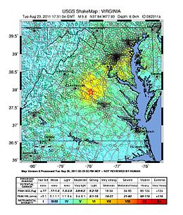
On August 23, 2011, a magnitude 5.8 earthquake hit the Piedmont region of the U.S. state of Virginia at 1:51:04 p.m. EDT. The epicenter, in Louisa County, was 38 mi (61 km) northwest of Richmond and 5 mi (8 km) south-southwest of the town of Mineral. It was an intraplate earthquake with a maximum perceived intensity of VIII (Severe) on the Mercalli intensity scale.[2] Several aftershocks, ranging up to 4.5 Mw in magnitude, occurred after the main tremor.
The quake was felt across more than a dozen U.S. states and in several Canadian provinces, and was felt by more people than any other quake in U.S. history.[5] No deaths and only minor injuries were reported. Minor and moderate damage to buildings was widespread and was estimated by one risk-modeling company at $200 million to $300 million, of which about $100 million was insured.[6][7]
The earthquake prompted research that revealed that the farthest landslide from the epicenter was 150 miles (240 km), by far the greatest landslide distance recorded from any other earthquake of similar magnitude. Previous studies of worldwide earthquakes indicated that landslides occurred no farther than 36 miles (58 km) from the epicenter of a magnitude 5.8 earthquake. The Virginia earthquake study suggested that the added information about East Coast earthquakes may prompt a revision of equations that predict ground shaking.
- ^ a b c "Magnitude 5.8 – Virginia". United States Geological Survey. Archived from the original on August 24, 2011. Retrieved August 23, 2011.
- ^ a b "M 5.8 – 11 km SSW of Mineral, Virginia". United States Geological Survey. Retrieved August 19, 2021.
- ^ "Pager– M 5.8– Virginia". United States Geological Survey. Archived from the original on September 6, 2015. Retrieved August 23, 2011.
- ^ Cite error: The named reference
Jibsonwas invoked but never defined (see the help page). - ^ Ruane, Michael E.; Aratani, Lori (August 23, 2012). "Earthquake damage to Washington Monument was very rare occurrence". The Washington Post.
- ^ Morello, Carol; Wiggins, Ovetta (August 24, 2011). "Region tallies earthquake damage, mostly uninsured". Washington Post.
- ^ Estimate by the Oakland, California-based catastrophe modeling and risk assessment company EQECAT, which estimated further that only 5 percent of East Coast property owners have earthquake coverage.
Hofmann, Mark A. (August 24, 2011). "Insured losses in East Coast earthquake less than $100M: EQECAT". Business Insurance.

