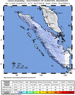
 | |
| UTC time | 2016-03-02 12:49:48 |
|---|---|
| ISC event | 611461544 |
| USGS-ANSS | ComCat |
| Local date | 2 March 2016 |
| Local time | 7:49 p.m local time (UTC+7) |
| Magnitude | 7.8 Mw |
| Depth | 24 km (15 mi) |
| Epicenter | 4°54′29″S 94°16′30″E / 4.908°S 94.275°E |
| Areas affected | Sumatra |
| Max. intensity | MMI V (Moderate)[1] |
| Tsunami | 0.54 m (1.8 ft)[2] |
| Casualties | None[3] |
The 2016 Sumatra earthquake was a 7.8 magnitude earthquake which struck on 2 March 2016 in the Indian Ocean, approximately 800 kilometers (500 miles) southwest of Sumatra in Indonesia.[4][5][6][7] Tsunami warnings were issued for Indonesia and Australia,[8] but were withdrawn two hours later.[9] There were no deaths directly related to the earthquake.[10]
- ^ "M7.8 - Southwest of Sumatra, Indonesia". United States Geological Survey. 9 April 2016. Retrieved 18 April 2016.
- ^ "M 7.8 in Southwest Of Sumatera, Indonesia on 02 Mar 2016 12:49 UTC". Global Disaster Alert and Coordination System.
- ^ "Aftershocks rock Indonesia after massive quake, calls for calm". Reuters. March 3, 2016. Retrieved March 3, 2016.
- ^ "POWERFUL QUAKE HITS OFF INDONESIA, TSUNAMI WARNING ISSUED". ABC7. Archived from the original on 4 March 2016. Retrieved 2 March 2016.
- ^ "M 7.8 - SOUTHWEST OF SUMATRA, INDONESIA - 2016-03-02 12:49:46 UTC". EMSC.
- ^ "Massive quake off west Sumatra, tsunami warning issued". The Star. Retrieved 2 March 2016.
- ^ "Earthquake affects the coast of Indonesia". 24 Horas. Retrieved 2 March 2016.
- ^ Rhian Lubin, Sam Webb (2 March 2016). "Indonesia earthquake: Tsunami fears after massive 7.9 magnitude quake hits". The Mirror.
- ^ "Powerful earthquake strikes near Indonesia". The Guardian. 2 March 2016.
- ^ "DFA: No Pinoys hurt in Indonesia quake". The Manila Times. March 3, 2016. Retrieved March 3, 2016.