| 2018 Lower Puna eruption | |
|---|---|
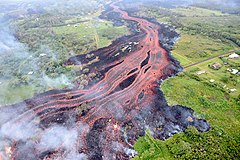
 ʻAʻā lava flows emerging from the elongated fissure 16–20 form channels on May 19, 2018 | |
| Volcano | Kīlauea's Lower East rift zone |
| Start date | May 3, 2018 |
| End date | September 4, 2018 |
| Type | Fissure eruption |
| Location | Hawaii Island, Hawaii, United States 19°27′47″N 154°53′56″W / 19.463°N 154.899°W |
| Impact | 24 injuries; lava fountains, lava flows; at least $800 million (2018 USD) in property damage; volcanic gas and earthquakes forced the evacuation of populated areas and destroyed houses, roads, and utilities.[1] |

The 2018 lower Puna eruption was a volcanic event on the island of Hawaiʻi, on Kīlauea volcano's East Rift Zone that began on May 3, 2018. It is related to the larger eruption of Kīlauea that began on January 3, 1983, though some volcanologists and USGS scientists have discussed whether to classify it as a new eruption.[2] Outbreaks of lava fountains up to 300 feet (90 m) high, lava flows, and volcanic gas in the Leilani Estates subdivision were preceded by earthquakes and ground deformation that created cracks in the roads.
On May 4, a 6.9 magnitude earthquake hit Puna. By May 27, 2018, 24 fissures had erupted lava in and near the Leilani Estates and Lanipuna Gardens subdivisions.[3][4] The eruption forced the evacuation of approximately two thousand residents. The Puna Geothermal Venture, which provided one-quarter of the island's electricity, was forced to shut down and was later damaged by lava. The fissures had sent lava rivers that buried part of Hawaii Route 137 on May 19, and began flowing into the ocean.[5]
On May 29, lava from a new northeastern flow overran Hawaii Route 132, cutting the access between Kapoho and Pāhoa.[6] The massive lava flow reached the Pacific Ocean at Kapoho Bay on June 4.[7][8] Lava entered the Kapoho Crater and evaporated Green Lake, which had been the largest natural freshwater lake in Hawaiʻi. On the night of June 4–5, the northeastern flow of lava speedily moved forward and destroyed the subdivision of Vacationland Hawaii.[9] By June 5, Kapoho Bay had been filled in with lava now forming a point where the bay had been.[10] The volcanic activity was the most destructive in the United States since the 1980 eruption of Mount St. Helens.[11]
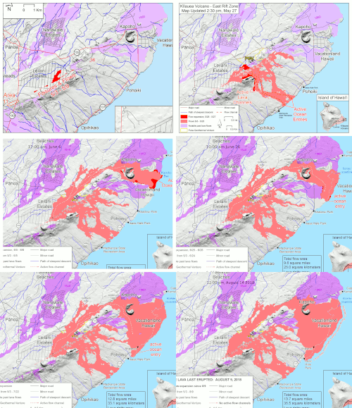
By August 7, 13.7 square miles (35 km2) of land had been covered by lava flows. About 875 acres (3.54 km2) of new land has been created in the ocean.[12][13] The official number of houses destroyed by the eruption reached 700 on July 9.[14] It was estimated that recovery efforts would cost more than $800 million (2018 USD).[15] By early August the eruption had almost completely subsided, and on December 5, it was declared to have ended after three months of inactivity.[16]
- ^ Cite error: The named reference
tour boatwas invoked but never defined (see the help page). - ^ Dayton, Kevin (May 31, 2018). "Scientists debate whether Leilani Estates eruption is 'new'". Star Advertiser. Archived from the original on June 13, 2018. Retrieved June 1, 2018.
- ^ Pang, Gordon Y.K. (May 19, 2018). "4 rescued by helicopter as lava cuts off access to about 40 houses". Honolulu Star-Advertiser. Archived from the original on May 20, 2018. Retrieved May 20, 2018.
- ^ Cite error: The named reference
0514 Kilauea updatewas invoked but never defined (see the help page). - ^ "Lava crosses Highway 137 and enters the ocean in lower Puna". Hawaii Tribune-Herald. May 19, 2018. Archived from the original on May 20, 2018. Retrieved May 20, 2018.
- ^ Burnett, John. "Fast-moving lava crosses Highway 132 in lower Puna". Hawaii Tribune-Herald. Archived from the original on May 30, 2018. Retrieved May 30, 2018.
- ^ "Fissure 8 lava flow moving north; laze creating plume at Kapoho Bay". Honolulu Star-Advertiser. June 3, 2018. Archived from the original on February 16, 2022. Retrieved June 4, 2018.
- ^ "Managing Director: Some residents defying voluntary evacuation order in Kapoho". Hawaii Tribune-Herald. Archived from the original on June 12, 2018. Retrieved June 4, 2018.
- ^ Bernardo, Rosemarie (June 5, 2018). "Lava destroys Big Isle mayor's home". Honolulu Star-Advertiser. Archived from the original on June 6, 2018. Retrieved June 5, 2018.
- ^ "Kīlauea lower East Rift Zone lava flows and fissures, June 5, 10:00 a.m. HST". USGS. June 5, 2018. Archived from the original on June 12, 2018. Retrieved June 6, 2018.
- ^ Sylvester, Terray (June 8, 2018). "Rivers of lava destroy 600 homes on Hawaii's Big Island: mayor". Reuters. Archived from the original on June 8, 2018. Retrieved June 8, 2018.
- ^ "Photo & Video Chronology". USGS. June 13, 2018. Archived from the original on July 13, 2018. Retrieved May 7, 2018.
- ^ "East Rift Zone map". USGS. August 7, 2018. Archived from the original on August 8, 2018. Retrieved August 8, 2018.
- ^ Burnett, John. "Official count of homes destroyed reaches 700". Hawaii Tribune-Herald. Archived from the original on July 10, 2018. Retrieved July 10, 2018.
- ^ Kevin Dayton (September 1, 2018). "Recovery from Kilauea eruption might cost $800M". Star Advertiser. Archived from the original on September 2, 2018. Retrieved September 1, 2018.
- ^ "Kilauea's eruption is technically over. But that doesn't mean it won't start up again". hawaiinewsnow.com. Archived from the original on March 28, 2019. Retrieved December 6, 2018.
