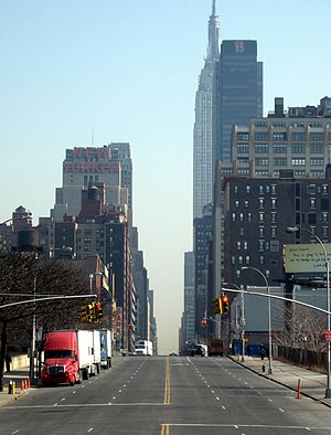
 From the west end of 34th Street, looking east (c. 2009) | |
 | |
| Maintained by | NYCDOT |
|---|---|
| Length | 2.0 mi (3.2 km)[1] |
| Location | Manhattan, New York City |
| Postal code | 10001, 10121, 10016 |
| Coordinates | 40°45′02″N 73°59′23″W / 40.7506°N 73.9896°W |
| West end | |
| East end | |
| North | 40th Street (west of 11th Avenue) 35th Street (east of 11th Avenue) |
| South | 33rd Street (west of 1st Avenue) 30th Street (east of 1st Avenue) |
| Construction | |
| Commissioned | March 1811 |
34th Street is a major crosstown street in the New York City borough of Manhattan. It runs the width of Manhattan Island from the West Side Highway on the West Side to FDR Drive on the East Side. 34th Street is used as a crosstown artery between New Jersey to the west and Queens to the east, connecting the Lincoln Tunnel to New Jersey with the Queens–Midtown Tunnel to Long Island.
Several notable buildings are located directly along 34th Street, including the Empire State Building, Macy's Herald Square, and Javits Center. Other structures, such as Pennsylvania Station, are located within one block of 34th Street. The street is served by the crosstown M34/M34A bus routes and contains several subway stops.
- ^ "34th Street (Manhattan)" (Map). Google Maps. Retrieved August 31, 2015.