| 49er Fire | |
|---|---|
 Flames appear behind a firefighting vehicle during the 49er Fire | |
| Date(s) |
|
| Location | Nevada County & Yuba County, California, United States |
| Coordinates | 39°19′41″N 121°06′40″W / 39.328°N 121.111°W |
| Statistics | |
| Burned area | 33,700 acres (13,638 ha; 53 sq mi; 136 km2) |
| Impacts | |
| Deaths | 0 |
| Non-fatal injuries | ≥500 |
| Evacuated | ≥8,000 |
| Structures destroyed | 312 |
| Damage |
|
| Ignition | |
| Cause | Burning debris |
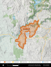
| Map | |
 The fire burned southwest from Highway 49 in a two-pronged arc over several days, crossing both the Yuba River and Highway 20. | |
The 49er Fire was a destructive wildfire in 1988 in Northern California's Nevada County and Yuba County. The fire ignited on September 11 when a man accidentally set brush on fire by burning toilet paper near Highway 49. Driven by severe drought conditions and strong, dry winds, firefighting crews were hard-pressed to stop the fire's advance until winds calmed and humidity levels recovered. The fire burned 33,700 acres (13,600 hectares) throughout the foothills of the Sierra Nevada, impinging on the communities of Lake Wildwood, Rough and Ready, and Smartsville before officials declared it fully contained on September 16.
The 49er Fire destroyed 312 structures, including more than 140 homes, making it the most destructive wildfire in Nevada County's history and—at the time—one of the five most destructive wildfires in recorded Californian history. It was also the seventh most expensive California wildfire in terms of losses, which amounted to approximately $23 million (equivalent to about $51 million in 2023). The 49er Fire highlighted the rapid pace and the potential consequences of development in the wildland-urban interface (WUI), and was sometimes called the 'wildfire of the 1990s' by state officials in an effort to raise awareness of the growing challenges of firefighting in areas where human structures intermingle with wildland fuels.
