A34 (numerous constituent roads) | |
|---|---|
 | |
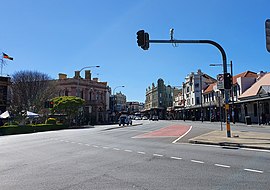
| Eastern end of A34 (Enmore Road) at Newtown | |
| Coordinates | |
| General information | |
| Type | Road |
| Length | 26.2 km (16 mi)[1] |
| Gazetted | August 1928[2] |
| Route number(s) | |
| Former route number | |
| Major junctions | |
| West end | Liverpool, Sydney |
| |
| East end | Newtown, Sydney |
| Location(s) | |
| Major suburbs | Milperra, Bankstown, Punchbowl, Lakemba, Canterbury, Dulwich Hill, Petersham, Enmore |
| Highway system | |
| ---- | |
The A34 is a route designation of a major metropolitan arterial route through suburban Sydney, linking Hume Highway at Liverpool and Princes Highway at Newtown, running parallel to the tolled M5 Motorway. This name covers a few consecutive roads and is widely known to most drivers, but the entire allocation is also known – and signposted – by the names of its constituent parts: Macquarie Street, Terminus Street, Newbridge Road, Milperra Road, (New) Canterbury Road, Stanmore Road and Enmore Road.[3]
- ^ "A34 road" (Map). Google Maps. Google. 17 May 2023. Retrieved 17 May 2023.
- ^ "Main Roads Act, 1924-1927". Government Gazette of the State of New South Wales. No. 110. National Library of Australia. 17 August 1928. pp. 3814–20. Archived from the original on 3 August 2022. Retrieved 1 August 2022.
- ^ "Spatial Information Exchange". New South Wales Land and Property Information.
