The article's lead section may need to be rewritten. The reason given is: needs clarification focus of article's topic - looks to be the settlement. May need split or refocus. (July 2020) |
Aaiha
عيحا | |
|---|---|
Village | |
 | |
| Country | |
| Governorate | Beqaa Governorate |
| District | Rashaya District |
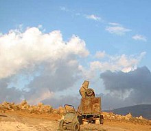
 A concrete mixer laying concrete on the central hill of the Aaiha plain, remains of stone walls behind | |
| Location | 2 kilometres (1.2 mi) northeast of Rashaya |
|---|---|
| Region | Bekaa Valley |
| Coordinates | 33°29′59″N 35°52′24″E / 33.49972°N 35.87333°E |
| History | |
| Cultures | Roman, Greek |
| Site notes | |
| Condition | Ruins |
| Public access | Yes |
Aaiha (or Aiha) (Arabic: عيحا) is a village, plain, lake, and temporary wetland situated in the Rashaya District and south of the Beqaa Governorate in Lebanon.[1][2] It is located in an intermontane basin near Mount Hermon and the Syrian border, approximately halfway between Rashaya and Kfar Qouq.[3]
The village sits c. 3,750 feet (1,140 m) above sea level and the small population is predominantly Druze.[3][4] Wild wheats Triticum boeoticum and T. urartu grow in this area, also used for farming goats.[5][6] There is a nearby tomb of a Muslim saint and a Roman ruins thought to be a temple or citadel that is now totally destroyed[3][7][8][9]
- ^ "Lebanon kfardenis, rachaya, kfar qouq, aaiha". www.discoverlebanon.com.
- ^ "Wild Lebanon - Powered by A Rocha Lebanon". www.wildlebanon.org. Archived from the original on 1 September 2016. Retrieved 10 April 2011.
- ^ a b c Edward Robinson; Eli Smith (1856). Biblical researches in Palestine, Mount Sinai and Arabia Petraea: A journal of travels in the year 1838. J. Murray. pp. 433–. Retrieved 10 April 2011.
- ^ British Druze Society - Druze communities in the Middle East Archived 11 September 2011 at the Wayback Machine
- ^ Anthony Elmit Hall; Glen H. Cannell (1979). Agriculture in semi-arid environments. Springer. ISBN 978-3-540-09414-2.
- ^ Sean Sheehan (January 1997). Lebanon. Marshall Cavendish. ISBN 978-0-7614-0283-1. Retrieved 11 April 2011.
- ^ Qada' (Caza) Rachaya - Promenade Tourist Brochure, published by The Lebanese Ministry of Tourism Archived 13 July 2011 at the Wayback Machine
- ^ Munir Said Mhanna (Photos by Kamal el Sahili), Rashaya el Wadi Tourist Brochure, p. 10, Lebanon Ministry of Tourism, Beirut, 2006
- ^ George Taylor (1971). The Roman temples of Lebanon: a pictorial guide. Les temples romains au Liban; guide illustré. Dar el-Machreq Publishers.
