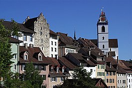
Aarau | |
|---|---|
 Aarau old town | |
| Coordinates: 47°24′N 8°03′E / 47.400°N 8.050°E | |
| Country | Switzerland |
| Canton | Aargau |
| District | Aarau |
| Government | |
| • Executive | Stadtrat with 7 members |
| • Mayor | Stadtpräsident (list) Hanspeter Hilfiker FDP/PRD (as of February 2018) |
| • Parliament | Einwohnerrat with 50 members |
| Area | |
| • Total | 12.34 km2 (4.76 sq mi) |
| Elevation | 381 m (1,250 ft) |
| Highest elevation (Hungerberg) | 471 m (1,545 ft) |
| Lowest elevation (Aar) | 365 m (1,198 ft) |
| Population (31 December 2018)[2] | |
| • Total | 21,503 |
| • Density | 1,700/km2 (4,500/sq mi) |
| Demonym | German: Aarauer(in) |
| Time zone | UTC+01:00 (Central European Time) |
| • Summer (DST) | UTC+02:00 (Central European Summer Time) |
| Postal code(s) | 5000, 5004 Aarau, 5032 Aarau Rohr |
| SFOS number | 4001 |
| ISO 3166 code | CH-AG |
| Localities | Aarau |
| Surrounded by | Buchs, Suhr, Unterentfelden, Eppenberg-Wöschnau, Erlinsbach |
| Twin towns | Neuchâtel (Switzerland), Delft (Netherlands), Reutlingen (Germany) |
| Website | www SFSO statistics |
Aarau (Swiss Standard German: [ˈaːraʊ], Alemannic German pronunciation: [ˈɑːræu̯]) is a town, a municipality, and the capital of the northern Swiss canton of Aargau. The town is also the capital of the district of Aarau. It is German-speaking and predominantly Protestant. Aarau is situated on the Swiss plateau, in the valley of the Aare, on the river's right bank, and at the southern foot of the Jura Mountains,[3] and is west of Zürich,[4] 58 kilometres (36 miles) south of Basel and 65 kilometres (40 miles) northeast of Bern.[5] The municipality borders directly on the canton of Solothurn to the west. It is the largest town in Aargau. At the beginning of 2010 Rohr became a district of Aarau.[6]
The official language of Aarau is (the Swiss variety of Standard) German, but the main spoken language is the local variant of the Alemannic Swiss German dialect.
- ^ a b "Arealstatistik Standard - Gemeinden nach 4 Hauptbereichen". Federal Statistical Office. Retrieved 13 January 2019.
- ^ "Ständige Wohnbevölkerung nach Staatsangehörigkeitskategorie Geschlecht und Gemeinde; Provisorische Jahresergebnisse; 2018". Federal Statistical Office. 9 April 2019. Retrieved 11 April 2019.
- ^ Bridgwater & Aldrich 1968, p. 11
- ^ Cite error: The named reference
EBwas invoked but never defined (see the help page). - ^ Van Valkenburg & Haefner 1997, p. 2
- ^ Oberholzer 2013


