| Aare Aar | |
|---|---|
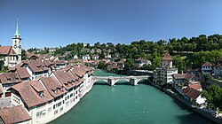
 The Aare at Bern | |
 Drainage basin of the Aare | |
| Location | |
| Country | Switzerland |
| Cantons | Bern, Solothurn, Aargau |
| Settlements | Meiringen (BE), Interlaken (BE), Thun (BE), Münsingen, Muri bei Bern, Bern, Bremgarten bei Bern, Aarberg (BE), Büren a.A. (BE), Solothurn (SO), Aarwangen (BE), Aarburg (BE), Olten (SO), Niedergösgen (SO), Schönenwerd (SO), Aarau (AG), Wildegg (AG), Brugg (AG), Windisch (AG), Döttingen (AG), Klingnau (AG) |
| Physical characteristics | |
| Source | |
| • location | Unteraar Glacier, Bernese Oberland |
| • coordinates | 46°34′07″N 8°11′16″E / 46.56858°N 8.18774°E |
| • elevation | 1,940 m (6,360 ft) |
| Mouth | |
• location | Rhine below Koblenz, Switzerland |
• coordinates | 47°36′21″N 8°13′24″E / 47.6057°N 8.2234°E |
• elevation | 311 m (1,020 ft) |
| Length | 291.5 kilometres (181.1 mi) [1] |
| Basin size | 17,779 km2 (6,865 sq mi) |
| Discharge | |
| • location | Untersiggenthal |
| • average | 559 m3/s (19,700 cu ft/s) (MQ 1935-2013) |
| • minimum | 351 m3/s (12,400 cu ft/s) (MNQ 1935-2013), 138 m3/s (4,900 cu ft/s) (NNQ, 1963) |
| • maximum | 735 m3/s (26,000 cu ft/s) (MHQ 1935-2013), 2,656 m3/s (93,800 cu ft/s) (HHQ, 2007) |
| Basin features | |
| Progression | Rhine→ North Sea |
| Tributaries | |
| • left | Lütschine (Lake Brienz), Kander (Lake Thun), Gürbe, Saane/La Sarine, Zihl/La Thielle (Lakes of Neuchatel and Bienne), La Suze (Lake of Bienne), Dünnern |
| • right | Gadmerwasser, Zulg, Emme, Murg, Wigger, Suhre, Aabach, Reuss, Limmat, Surb |
| Waterbodies | Oberaarsee, Grimselsee, Räterichsbodensee, Lake Brienz, Lake Thun, Wohlensee, Lake Biel, Stausee Niederried, Klingnauer Stausee |
 | |
The Aare (Swiss Standard German: [ˈaːrɛ] ) or Aar (Swiss Standard German: [aːr] ) is the main tributary of the High Rhine (its discharge even exceeds that of the latter at their confluence)[2] and the longest river that both rises and ends entirely within Switzerland.[3][4]
Its total length from its source to its junction with the Rhine comprises about 295 kilometres (183 mi),[3][5] during which distance it descends 1,565 m (5,135 ft), draining an area of 17,779 km2 (6,865 sq mi), almost entirely within Switzerland, and accounting for close to half the area of the country, including all of Central Switzerland.[5]
There are more than 40 hydroelectric plants along the course of the Aare.[6]
The river's name dates to at least the La Tène period, and it is attested as Nantaror "Aare valley" in the Berne zinc tablet.
The name was Latinized as Arula/Arola/Araris.[7][nb 1]
- ^ Geoserver of the Swiss Confederation
- ^ "High Rhine". ICPR – International Commission for the Protection of the Rhine. Retrieved 2024-06-15.
- ^ a b Bridgwater & Aldrich 1968, p. 11
- ^ Cite error: The named reference
GHwas invoked but never defined (see the help page). - ^ a b Hoiberg 2010, p. 4
- ^ Cite error: The named reference
cohenwas invoked but never defined (see the help page). - ^ Kristol et al. 2005, p. 73
- ^ Forbiger 1848, p. 126f
Cite error: There are <ref group=nb> tags on this page, but the references will not show without a {{reflist|group=nb}} template (see the help page).
