| Abrahamskraal Formation | |
|---|---|
| Stratigraphic range: Wordian-Capitanian ~ | |
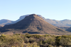
 Hill with outcropping Teekloof and Abrahamskraal Formations | |
| Type | Geological formation |
| Unit of | Beaufort Group |
| Sub-units | Tapinocephalus Assemblage Zone, Eodicynodon Assemblage Zone |
| Underlies | Teekloof Formation |
| Overlies | Ecca Group |
| Thickness | up to 2,565 m (8,415 ft) |
| Lithology | |
| Primary | Mudstone, sandstone |
| Other | Siltstone |
| Location | |
| Coordinates | 31°24′S 23°06′E / 31.400°S 23.100°E |
| Approximate paleocoordinates | 59°54′S 38°54′W / 59.9°S 38.9°W |
| Region | Northern, Western & Eastern Cape |
| Country | |
| Type section | |
| Named for | Abrahams Kraal 29 (farm), 18 km south of Leeu-Gamka |
| Named by | A.W. Keyser, P.J. Rossouw & Lieuwe Dirk Boonstra |
 A simplified geological map of the outcrops of Karoo Supergroup rocks in Southern Africa. The Beaufort Group is represented by the yellow key on the map. | |
The Abrahamskraal Formation is a geological formation and is found in numerous localities in the Northern Cape, Western Cape, and the Eastern Cape of South Africa. It is the lowermost formation of the Adelaide Subgroup of the Beaufort Group, a major geological group that forms part of the greater Karoo Supergroup. It represents the first fully terrestrial geological deposits of the Karoo Basin. Outcrops of the Abrahamskraal Formation are found from the small town Middelpos in its westernmost localities, then around Sutherland, the Moordenaarskaroo north of Laingsburg, Williston, Fraserburg, Leeu-Gamka, Loxton, and Victoria West in the Western Cape and Northern Cape. In the Eastern Cape outcrops are known from Rietbron, north of Klipplaat and Grahamstown, and also southwest of East London.[1][2]
- ^ Day, M. O.; Rubidge, B. S. (2014-12-01). "A brief lithostratigraphic review of the Abrahamskraal and Koonap formations of the Beaufort Group, South Africa: Towards a basin-wide stratigraphic scheme for the Middle Permian Karoo". Journal of African Earth Sciences. 100: 227–242. Bibcode:2014JAfES.100..227D. doi:10.1016/j.jafrearsci.2014.07.001. ISSN 1464-343X.
- ^ Merrill van der Walt; Michael Day; Bruce Rubidge; Antony K. Cooper; Inge Netterberg (2010). "A new GIS-based biozone map of the Beaufort Group (Karoo Supergroup), South Africa". Palaeontologia Africana. 45: 1–6. Retrieved 2018-11-27.