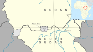
Abyei Area
منطقة أبيي mintaqat 'abyi | |
|---|---|
| Abyei Area Administration | |
 Location | |
| Countries | |
| Comprehensive Peace Agreement | 9 January 2005 |
| Headquarters | Abyei Town |
| Government | |
| • Type | Abyei Area Administration |
| • Chief Administrator | Chol Deng Alak[1] |
| Area | |
• Total | 10,546 km2 (4,072 sq mi) |
| Population (2014) | |
• Total | 124,390[citation needed] |
| Time zone | UTC+02:00 (CAT) |
| Website | https://abyei.gov.ss/ |
The Abyei Area (Arabic: منطقة أبيي) is an area of 10,546 km2 or 4,072 sq mi[2] on the border between South Sudan and Sudan that has been accorded "special administrative status" by the 2004 Protocol on the Resolution of the Abyei Conflict (Abyei Protocol) in the Comprehensive Peace Agreement (CPA) that ended the Second Sudanese Civil War.[3] The capital of the Abyei Area is Abyei Town. Under the terms of the Abyei Protocol, the Abyei Area is considered, on an interim basis, to be simultaneously part of both the Republic of South Sudan and Republic of Sudan, effectively a condominium.
In contrast to the borders of the former district, the Abyei Protocol defined the Abyei Area as "the area of the nine Ngok Dinka chiefdoms transferred to Kordofan in 1905".[3] In 2005, a multinational border commission established this to be those portions of Kordofan south of 10°22′30″ N.[4] However, following continued disputes that erupted into violence and threatened the CPA, an international arbitration process redrew Abyei's boundaries in 2009 to make it significantly smaller, extending no further north than 10°10′00" N.[5] This revised border has now been endorsed by all parties to the dispute.[citation needed]
- ^ "South Sudan's Kiir appoints new Chief Administrator for Abyei". Sudan Tribune. 10 January 2023. Retrieved 19 August 2024.
- ^ GETTLEMAN, JEFFREY (25 May 2011). "U.N. Warns of Ethnic Cleansing in Sudan Town". The New York Times. Retrieved 15 November 2012.
- ^ a b “Protocol on the resolution of Abyei conflict”, Government of the Republic of Sudan and the Sudan People’s Liberation Movement/Army, 26 May 2004 (hosted by reliefweb.int)
- ^ “Why Abyei Matters”, African Affairs, 107/426, 1–19, 23 December 2007
- ^ "The Government of Sudan / The Sudan People's Liberation Movement/Army (Abyei Arbitration)". Permanent Court of Arbitration. Archived from the original on 20 November 2011. Retrieved 22 July 2009.

