Adair, Oklahoma | |
|---|---|
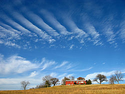
 A farm in Adair, Oklahoma | |
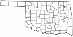
 Location of Adair, Oklahoma | |
| Coordinates: 36°26′13″N 95°16′25″W / 36.43694°N 95.27361°W | |
| Country | United States |
| State | Oklahoma |
| County | Mayes |
| Area | |
• Total | 4.92 sq mi (12.73 km2) |
| • Land | 4.92 sq mi (12.73 km2) |
| • Water | 0.00 sq mi (0.00 km2) |
| Elevation | 679 ft (207 m) |
| Population (2020) | |
• Total | 732 |
| • Density | 148.93/sq mi (57.50/km2) |
| Time zone | UTC-6 (Central (CST)) |
| • Summer (DST) | UTC-5 (CDT) |
| ZIP code | 74330 |
| Area codes | 539/918 |
| FIPS code | 40-00250[3] |
| GNIS feature ID | 2412333[2] |
Adair is a town in Mayes County, Oklahoma, United States. The population was 790 at the 2010 census, compared to the figure of 704 recorded in 2000.[4] Named for two prominent Cherokee brothers, the town was established in 1883. It opened a Cherokee school.[5]
- ^ "ArcGIS REST Services Directory". United States Census Bureau. Retrieved September 20, 2022.
- ^ a b U.S. Geological Survey Geographic Names Information System: Adair, Oklahoma
- ^ "U.S. Census website". United States Census Bureau. Retrieved January 31, 2008.
- ^ Pryor Daily Times. "Mayes County grows by 3,000. April 4, 2011. Retrieved September 14, 2011.[1] Archived July 23, 2014, at the Wayback Machine
- ^ Cite error: The named reference
okhizwas invoked but never defined (see the help page).