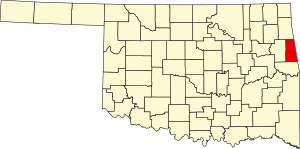
Adair County | |
|---|---|
 | |
 Location within the U.S. state of Oklahoma | |
 Oklahoma's location within the U.S. | |
| Coordinates: 35°53′N 94°40′W / 35.88°N 94.66°W | |
| Country | |
| State | |
| Founded | July 16, 1907 |
| Named for | The Adair family of the Cherokee tribe. |
| Seat | Stilwell |
| Largest city | Stilwell |
| Area | |
• Total | 577 sq mi (1,490 km2) |
| • Land | 573 sq mi (1,480 km2) |
| • Water | 3.6 sq mi (9 km2) 0.6% |
| Population (2020) | |
• Total | 19,495 |
| • Density | 34/sq mi (13/km2) |
| Time zone | UTC−6 (Central) |
| • Summer (DST) | UTC−5 (CDT) |
| Congressional district | 2nd |
Adair County is a county located in the U.S. state of Oklahoma. As of the 2020 census, the population was 19,495.[1] Its county seat is Stilwell.[2] Adair County was named after the Adair family of the Cherokee tribe.[3] One source says that the county was specifically named for Watt Adair, one of the first Cherokees to settle in the area.[4] Adair County is part of the Cherokee Nation reservation.
- ^ "Adair County, Oklahoma". United States Census Bureau. Retrieved May 9, 2023.
- ^ "Find a County". National Association of Counties. Archived from the original on May 31, 2011. Retrieved June 7, 2011.
- ^ Oklahoma Almanac Online (PDF). Oklahoma Department of Libraries.
- ^ "Stilwell is part of 'Green County Oklahoma'"" Archived February 7, 2015, at the Wayback Machine Retrieved September 14, 2014.