Adalaj | |
|---|---|
Town | |
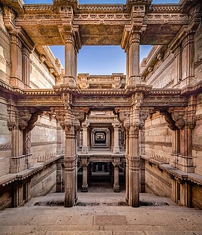
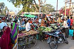
Clockwise: Adalaj stepwell, a market, and Trimandir temple. | |
 | |
| Coordinates: 23°10′N 72°35′E / 23.17°N 72.58°E | |
| Country | |
| State | Gujarat |
| District | Gandhinagar |
| Taluka | Gandhinagar |
| Government | |
| • Type | Panchayat |
| • Gram Panchayat | Kokilaben R Thakor |
| Area | |
• Town | 17.91 km2 (6.92 sq mi) |
| • Land | 17.91 km2 (6.92 sq mi) |
| • Urban | 17.91 km2 (6.92 sq mi) |
| Elevation | 66 m (217 ft) |
| Highest elevation | 69 m (226 ft) |
| Lowest elevation | 63 m (207 ft) |
| Population (2011) | |
• Town | 11,957 |
| • Rank | 1,262 |
| • Density | 670/km2 (1,700/sq mi) |
| Languages | |
| • Official | Gujarati, Hindi |
| Time zone | UTC+5:30 (IST) |
| PIN | 382 421 |
| STD code | +91-2712 |
| Vehicle registration | GJ |
| Website | Gandhinagar District Panchayat |
| [1][2] | |
Adalaj is a census town in Gandhinagar district located in the western Indian state of Gujarat.[1] With a population of roughly 12,000 residents within the town limits as of 2011, Adalaj is known for its semi-arid climate and its historic and religious establishments. The town sits in a generally flat area covering about 18 sq. km.
The city has seen recent rapid urbanization since the last census report.
- ^ a b Parimal, Jayant (2006). Census of India 2001, District Census Handbook, Part XII A & B, Gandhinagar District, Village & Town Directory (PDF) (Report). New Delhi: Government of India. pp. xxiv, 5, 32, 60, 67–68. Archived (PDF) from the original on 14 June 2022. Retrieved 13 June 2022.
- ^ "ગાંધીનગર સરપંચ લિસ્ટ (Sarpanch List)". ગાંધીનગર તાલુકા પંચાયત (in Gujarati). Government of Gujarat. 16 June 2020. Retrieved 9 January 2023.


