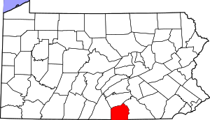
Adams County | |
|---|---|
 | |
 Location within the U.S. state of Pennsylvania | |
 Pennsylvania's location within the U.S. | |
| Coordinates: 39°52′N 77°13′W / 39.87°N 77.22°W | |
| Country | |
| State | |
| Founded | January 22, 1800 |
| Named for | John Adams |
| Seat | Gettysburg |
| Largest borough | Gettysburg |
| Area | |
| • Total | 522 sq mi (1,350 km2) |
| • Land | 519 sq mi (1,340 km2) |
| • Water | 3.1 sq mi (8 km2) 0.6% |
| Population (2020) | |
| • Total | 103,852 |
| • Estimate (2022) | 106,027 |
| • Density | 200/sq mi (80/km2) |
| Time zone | UTC−5 (Eastern) |
| • Summer (DST) | UTC−4 (EDT) |
| Congressional district | 13th |
| Website | www |
| Type | City |
| Designated | November 6, 1982[1] |
Adams County is a county in the Commonwealth of Pennsylvania. As of the 2020 census, the population was 103,852.[2] Its county seat is Gettysburg.[3] The county was created on January 22, 1800, from part of York County, and was named for the second President of the United States, John Adams. On July 1–3, 1863, a crucial battle of the American Civil War was fought near Gettysburg; Adams County, as a result, is a center for Civil War-related tourism. The county is part of the South Central Pennsylvania region of the state.[a] Adams County comprises the Gettysburg metropolitan statistical area, which is also included in the Harrisburg–York–Lebanon combined statistical area.
- ^ "PHMC Historical Markers Search". Pennsylvania Historical and Museum Commission. Commonwealth of Pennsylvania. Archived from the original (Searchable database) on March 21, 2016. Retrieved January 25, 2014.
- ^ "Census - Geography Profile: Adams County, Pennsylvania". United States Census Bureau. Retrieved April 24, 2022.
- ^ "Find a County". National Association of Counties. Archived from the original on May 31, 2011. Retrieved June 7, 2011.
Cite error: There are <ref group=lower-alpha> tags or {{efn}} templates on this page, but the references will not show without a {{reflist|group=lower-alpha}} template or {{notelist}} template (see the help page).
