Adamsville, Alabama | |
|---|---|
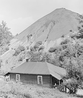
 Porter Mine Company Housing for Black Miner in Adamsville, 1946 | |
| Nickname: Adam | |
 Location of Adamsville in Jefferson County, Alabama. | |
| Coordinates: 33°35′25″N 86°56′57″W / 33.59028°N 86.94917°W | |
| Country | United States |
| State | Alabama |
| County | Jefferson |
| Government | |
| • Mayor | Pam Palmer |
| Area | |
| • Total | 26.42 sq mi (68.44 km2) |
| • Land | 26.21 sq mi (67.90 km2) |
| • Water | 0.21 sq mi (0.54 km2) 0.05% |
| Elevation | 574 ft (175 m) |
| Population (2020) | |
| • Total | 4,366 |
| • Density | 166.55/sq mi (64.30/km2) |
| Time zone | UTC-6 (CST) |
| • Summer (DST) | UTC-5 (CDT) |
| ZIP code | 35005 |
| Area codes | 205 & 659 |
| FIPS code | 01-00460 |
| GNIS feature ID | 112930[2] |
| Website | www.cityofadamsville.org |
Adamsville is a city in western Jefferson County, Alabama. It is north from the Birmingham suburb of Pleasant Grove. It initially incorporated in 1901 (although the 1910 U.S. Census stated 1900), but disincorporated in 1915.[3] It later reincorporated in 1953.[4] According to the 2010 census, this town had a population of 4,522, down from its peak population of 4,965 in 2000.
- ^ "2020 U.S. Gazetteer Files". United States Census Bureau. Retrieved October 29, 2021.
- ^ a b U.S. Geological Survey Geographic Names Information System: Adamsville, Alabama
- ^ Jefferson County Archived October 1, 2019, at the Wayback Machine. Adamsville charter adopted 1900, dissolved 1915
- ^ "Adamsville - Encyclopedia of Alabama". Encyclopedia of Alabama.