Adel, Oregon | |
|---|---|
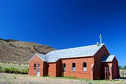
 Saint Richard Catholic Church in Adel | |
| Coordinates: 42°10′39″N 119°53′51″W / 42.1775°N 119.8974°W | |
| Country | United States |
| State | Oregon |
| County | Lake |
| Elevation | 4,547 ft (1,386 m) |
| Time zone | UTC-8 (Pacific) |
| • Summer (DST) | UTC-7 (Pacific) |
| Zip Code | 97620 |
| Elevation from the Geographic Names Information System[1] | |
Adel is an unincorporated community in southeastern Lake County, in the U.S. state of Oregon. The community is in an arid, sparsely populated part of the state, along Oregon Route 140, about 30 miles (48 km) east of Lakeview. The Warner Valley surrounding Adel contains many marshes and shallow lakes, most of them intermittent.
Frequented by Native Americans for many thousands of years, the valley became a region of sheep grazing and cattle ranching by the late 19th century. Adel's infrastructure includes a combined store/restaurant/bar, a post office (serving Zip Code 97620), an elementary school, and a church. Hot springs and related geological features have made one of the nearby ranches a potential site for a geothermal power station.
- ^ "Adel, Oregon". Geographic Names Information System (GNIS). United States Geological Survey. November 28, 1980. Retrieved June 20, 2015.

