| Aden Crater | |
|---|---|
 Aden Crater, New Mexico | |
| Highest point | |
| Elevation | 4,477 ft (1,365 m)[1] |
| Coordinates | 32°04′10″N 107°03′29″W / 32.0695412°N 107.058066°W[2] |
| Geography | |
| Location | Doña Ana County, New Mexico, U.S. |
| Topo map | USGS Aden Crater |
| Geology | |
| Mountain type | shield volcano |
| Volcanic field | Potrillo volcanic field |
| Last eruption | ca. 16,000 years ago |
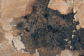
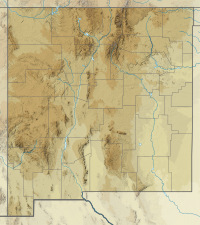
Aden Crater is a small shield volcano located in Doña Ana County, about 25 miles (40 km) southwest of Las Cruces, New Mexico.[3] It is located in the northwest part of the Aden-Afton basalt field, which is part of the central area of the Potrillo volcanic field.[4][5]
A fossilized ground sloth,[6] now at the Peabody Museum, was found in a fumarole roughly 100' deep located on the SE portion of the crater rim. Several ground sloth coprolites were also recovered and were stored in the Geology department at UTEP.[7]
No volcanic activity at Aden Crater is known from historic times. The most recent known activity has been dated to roughly 16,000 years ago.[8]
The flows associated with the crater can be divided into two groups. The earlier lavas were more fluid and formed most of the flows to the east and south of the crater. These flows are characterized by inflation plateaus, formed when a solid crust begins to develop around a flow and the lava inflates the more ductile upper surface of the flow. The second group of flows were less fluid and accumulated closer to the vent to form the shield of the crater.[9]
- ^ "Aden Crater". ListsOfJohn.com. Retrieved February 10, 2014.
- ^ "Aden Crater". Geographic Names Information System. United States Geological Survey, United States Department of the Interior. Retrieved February 10, 2014.
- ^ Hoffer, Jerry M. (1975). "A note on the volcanic features of the Aden Crater area, southcentral New Mexico" (PDF). New Mexico Geological Society Field Conference Series. 26: 131–134. Retrieved November 16, 2020.
- ^ Hoffer, Jerry M.; Penn, Brian S.; Quezada, Oscar A.; Morales, Monica (1998). "Qualitative age relationships of late Cenozoic cinder cones, southern Rio Grande rift, using cone morphology and LANDSAT thematic imagery: A preliminary assessment" (PDF). New Mexico Geological Society Field Guide. 49: 123–128. Retrieved November 13, 2020.
- ^ "New Mexico Volcanoes and Volcanics". USGS/Cascades Volcano Observatory. Retrieved February 10, 2014.
- ^ Sharp, Jay W. "Potrillo Volcanic Field". DesertUSA. Retrieved February 10, 2014.
- ^ Simons, Elwyn L.; Alexander, H. L. (January 1964). "Age of the Shasta Ground Sloth from Aden Crater, New Mexico". American Antiquity. 29 (3): 390–391. doi:10.2307/277883. JSTOR 277883.
- ^ Anthony E. Y.; Poths J. (1992). "3He Aden Crater, Rio Grande Rift, New Mexico, USA". Geochimica et Cosmochimica Acta. 56: 4105–4108. doi:10.1016/0016-7037(92)90022-b.
- ^ DeHon, R.A.; Earl, R.A. (2018). "The Aden lava flows, Doña Ana County, New Mexico" (PDF). New Mexico Geological Society Field Conference Series. 69: 197–202. Retrieved March 11, 2021.
