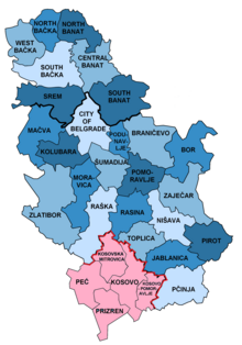
| Administrative districts Управни окрузи | |
|---|---|
 | |
| Category | Unitary state |
| Location | Serbia |
| Created |
|
| Number | 24 (29 including Kosovo) + City of Belgrade |
| Populations | 77,341 (Toplica) – 607,178 (South Bačka) |
| Areas | 1,248 km2 (482 sq mi) (Podunavlje) – 6,140 km2 (2,370 sq mi) (Zlatibor) |
 |
|---|
|
|
The administrative districts (Serbian: управни окрузи, romanized: upravni okruzi) of Serbia are the country's first-level administrative division. The term okrug (pl. okruzi) means "circuit" and corresponds (in literal meaning) to bezirk in German language. It can be translated as "county", though it is generally rendered by the government as "district". Prior to a 2006 decree, the administrative districts were named simply districts.
The local government reforms of 1992, going into effect the following year, created 29 districts, with the City of Belgrade having similar status.[1] Following the 2008 Kosovo declaration of independence, the districts created by the UNMIK-Administration were adopted by Kosovo. The Serbian government does not recognize these districts.
The administrative districts are generally named after historical and geographical regions, though some, such as the Pčinja District and the Nišava District, are named after local rivers. Their areas and populations vary, ranging from the relatively-small Podunavlje District to the much larger Zlatibor District.
As they are mere designations of territorial remit of regional administrative centres through which the central government exercises its power within a hierarchical order, the districts are distinctly not units of regional self-governance, and as such they do not have flags. Still, they are each run by a commissioner as well as cooperating municipal leaders. Rather than being further divisible into municipalities, each district overlaps with its corresponding cluster of municipalities (which are units of local self-government).
- ^ "Facts about Serbia". Government of Serbia. Retrieved 2008-09-29.