| Adolphe-Poisson Bay | |
|---|---|
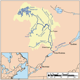
 Watershed of Saint-Maurice River | |
| Location | La Tuque |
| Coordinates | 48°27′02″N 75°24′14″W / 48.45056°N 75.40389°W |
| Type | Baie of dam |
| Primary inflows |
|
| Primary outflows | Hanotaux Bay, Du Mâle Lake |
| Basin countries | Canada |
| Max. length | 15.2 kilometres (9.4 mi) |
| Max. width | 3.2 kilometres (2.0 mi) |
| Surface elevation | 402 metres (1,319 ft) |
The Adolphe-Poisson Bay is a freshwater body located south of the southwestern part of the Gouin Reservoir, in the territory of the town of La Tuque, in the administrative region of Mauricie, in the province of Quebec, in Canada.
This lake extends almost entirely in Poisson Township (southern part), except for the strait passing to the northeast of the large island blocking the mouth of the bay which is situated in the canton of Hanotaux.
Recreotourism activities are the main economic activity of the sector. Forestry comes second.
The Forest Road R1009 passes on the west side of Adolphe-Poisson Bay and also serves the lower Flapjack River, passing through the northern part of Bignell Creek and the southern part of the Bureau Lake (Gouin Reservoir). This R1009 road joins the Southeast route 404 which serves the northern part of the Canadian National Railway.
The surface of Adolphe-Poisson Bay is usually frozen from mid-November to the end of April, however, safe ice circulation is generally from early December to late March.
