Adurru | |
|---|---|
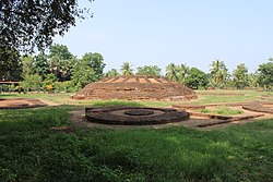
 Ruins of a Buddhist stupa at Adurru | |
 Dynamic map | |
| Coordinates: 16°28′43″N 81°57′16″E / 16.478552°N 81.954523°E | |
| Country | |
| State | Andhra Pradesh |
| District | Dr. B.R. Ambedkar Konaseema |
| Mandal | Mamidikuduru |
| Area | |
| • Total | 5.61 km2 (2.17 sq mi) |
| Population (2011)[1] | |
| • Total | 4,145 |
| • Density | 740/km2 (1,900/sq mi) |
| Languages | |
| • Official | Telugu |
| Time zone | UTC+5:30 (IST) |
| PIN | 533247 |
Adurru is a village and a 2nd-century CE Buddhist archaeological site[2] in the Dr. B.R. Ambedkar Konaseema district of Andhra Pradesh, India. It is located in the Mamidikuduru Mandal, on the western bank of Vainateya, a distributary of the Godavari River,[3] around 9.5 km from the Bay of Bengal.[4]
- ^ a b Cite error: The named reference
DCHB_2011was invoked but never defined (see the help page). - ^ Garima Kaushik (2016), Women and Monastic Buddhism in Early South Asia, Taylor & Francis, ISBN 978-1-317-32939-8, Appendix Table 4: Buddhist stupa sites in India, with Ayala projections
- ^ J. Krishna Kumari (2013). Buddhist Monuments: Their Role in the Development of Tourism in Andhra Pradesh. Readworthy. p. 276. ISBN 978-81-935345-6-4.
- ^ Cite error: The named reference
TH_VVS_ignoredwas invoked but never defined (see the help page).
