| Agate Lake | |
|---|---|
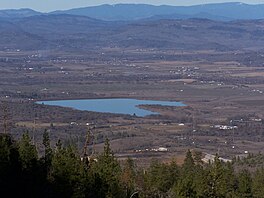
 Agate Lake from Roxy Ann Peak | |
 A map of Agate Lake | |
| Location | Jackson County, Oregon |
| Coordinates | 42°24′39.05″N 122°46′13.65″W / 42.4108472°N 122.7704583°W[1] |
| Type | Reservoir |
| Primary inflows | Dry Creek, Antelope Creek[a] |
| Primary outflows | Dry Creek |
| Basin countries | United States |
| Surface area | 216 acres (0.87 km2) |
| Average depth | 68 feet (21 m)[2] |
| Max. depth | 72 feet (22 m)[b][2] |
| Water volume | 4,782 acre-feet (5,899,000 m3) |
| Shore length1 | 3 miles (4.8 km) |
| Surface elevation | 1,510 feet (460 m) |
| 1 Shore length is not a well-defined measure. | |
Agate Lake is a reservoir located 1,510 feet (460 m) above sea level in Jackson County, Oregon, United States. It is 13 miles (21 km) northeast of Medford,[3] just north of Roxy Ann Peak. The lake is formed by the 86-foot (26 m) tall Agate Dam, which impounds Dry Creek, in the Rogue River watershed.
- ^ "Agate Reservoir". Geographic Names Information System. United States Geological Survey, United States Department of the Interior. Retrieved Jan 17, 2021.
- ^ a b c "Projects & Facilities - Dams - Agate Dam". Bureau of Reclamation. Details. Retrieved 2021-02-18.
- ^ "Rogue River Basin Project". United States Bureau of Reclamation. Archived from the original on June 14, 2011. Retrieved August 10, 2009.
Cite error: There are <ref group=lower-alpha> tags or {{efn}} templates on this page, but the references will not show without a {{reflist|group=lower-alpha}} template or {{notelist}} template (see the help page).

