Agia Varvara
Αγία Βαρβάρα | |
|---|---|
 The church of Agia Varvara | |
| Coordinates: 35°08′N 25°00′E / 35.133°N 25.000°E | |
| Country | Greece |
| Administrative region | Crete |
| Regional unit | Heraklion |
| Municipality | Gortyn |
| Area | |
| • Municipal unit | 99.0 km2 (38.2 sq mi) |
| Elevation | 580 m (1,900 ft) |
| Population (2021)[1] | |
| • Municipal unit | 4,241 |
| • Municipal unit density | 43/km2 (110/sq mi) |
| • Community | 2,096 |
| Time zone | UTC+2 (EET) |
| • Summer (DST) | UTC+3 (EEST) |
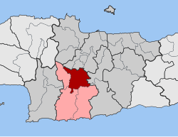
Agia Varvara (Greek: Αγία Βαρβάρα) is a village and a former municipality in the Heraklion regional unit, Crete, Greece. Since the 2011 local government reform it is part of the municipality Gortyn, of which it is a municipal unit.[2] The municipal unit has an area of 99.038 km2 (38.239 sq mi).[3] Population 4,241 (2021). The village lies at an altitude of about 580 meters and has 2,096 inhabitants.
Agia Varvara lies on the busy north–south road from Heraklion on the north coast of the island towards the centre.
- ^ "Αποτελέσματα Απογραφής Πληθυσμού - Κατοικιών 2021, Μόνιμος Πληθυσμός κατά οικισμό" [Results of the 2021 Population - Housing Census, Permanent population by settlement] (in Greek). Hellenic Statistical Authority. 29 March 2024.
- ^ "ΦΕΚ B 1292/2010, Kallikratis reform municipalities" (in Greek). Government Gazette.
- ^ "Population & housing census 2001 (incl. area and average elevation)" (PDF) (in Greek). National Statistical Service of Greece. Archived from the original (PDF) on 2015-09-21.

