Agua Caliente | |
|---|---|
Neighborhood | |
 Tower of Agua Caliente replica. | |
| Coordinates: 32°30′34″N 116°59′35″W / 32.50944°N 116.99306°W | |
| Country | Mexico |
| State | Baja California |
| City | Tijuana |
| Time zone | UTC-8 (Pacific Time Zone) |
| • Summer (DST) | UTC-7 (Pacific Daylight Time) |
| ZIP Code | 22000 |
| Area code | 664 |
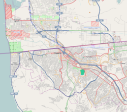
Agua Caliente is a historic entertainment center and present-day district of Tijuana, Baja California, at the southeastern end of the Centro borough. The Agua Caliente Tourist Complex formed in the late 1920s along Agua Caliente Boulevard when a road was built that led from the historic Rio Zone to a natural hot springs two miles up the Tijuana River Valley. Paramount icons of Tijuana developed in Agua Caliente such as the Agua Caliente Casino and Hotel and the Agua Caliente Racetrack. Today Agua Caliente is one of Tijuana's paramount tourist centers, the location of some of the city's most affluent neighborhoods, and also contains commercial and other offices along Boulevard Agua Caliente.
