Ahwahnee, California | |
|---|---|
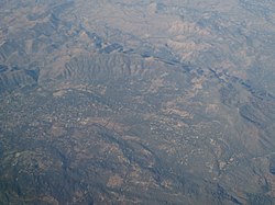
 Aerial view of Ahwahnee | |
| Coordinates: 37°21′56″N 119°43′35″W / 37.36556°N 119.72639°W | |
| Country | |
| State | |
| County | Madera |
| Area | |
• Total | 11.54 sq mi (29.90 km2) |
| • Land | 11.54 sq mi (29.90 km2) |
| • Water | 0.00 sq mi (0.00 km2) 0% |
| Elevation | 2,326 ft (709 m) |
| Population | |
• Total | 2,296 |
| • Density | 198.91/sq mi (76.80/km2) |
| Time zone | UTC-8 (Pacific (PST)) |
| • Summer (DST) | UTC-7 (PDT) |
| ZIP Code | 93601 |
| Area code | 559 |
| GNIS feature IDs | 256142;[4] 2628702[5] |
| FIPS code | 06-00478 |
Ahwahnee is a census-designated place[6] in Madera County, California, United States.[2] It is located 5.25 miles (8.4 km) west of Yosemite Forks,[7] at an elevation of 2,326 feet (709 m).[2] The population was 2,296 at the 2020 census.[3]
Ahwahnee is hilly and located in the Sierra Nevada. The ZIP Code is 93601. The community is inside area code 559. It is part of the Madera–Chowchilla Metropolitan Statistical Area.
- ^ "2021 U.S. Gazetteer Files: California". United States Census Bureau. Retrieved June 24, 2022.
- ^ a b c U.S. Geological Survey Geographic Names Information System: Ahwahnee, California
- ^ a b "P1. Race – Ahwanee CDP, California: 2020 DEC Redistricting Data (PL 94-171)". U.S. Census Bureau. Retrieved June 24, 2022.
- ^ "Ahwahnee". Geographic Names Information System. United States Geological Survey, United States Department of the Interior.
- ^ "Ahwahnee Census Designated Place". Geographic Names Information System. United States Geological Survey, United States Department of the Interior.
- ^ U.S. Geological Survey Geographic Names Information System: Ahwahnee, California
- ^ Durham, David L. (1998). California's Geographic Names: A Gazetteer of Historic and Modern Names of the State. Clovis, Calif.: Word Dancer Press. p. 739. ISBN 1-884995-14-4.

