ʻAiea | |
|---|---|
 View overlooking Pearl Harbor and Aloha Stadium from the Aiea Heights neighborhood of Aiea | |
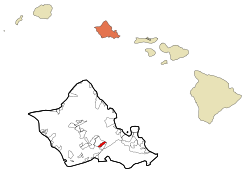
 Location in Honolulu County and the state of Hawaii | |
| Coordinates: 21°23′9″N 157°55′51″W / 21.38583°N 157.93083°W | |
| Country | |
| State | |
| County | Honolulu |
| Area | |
• Total | 1.77 sq mi (4.58 km2) |
| • Land | 1.66 sq mi (4.30 km2) |
| • Water | 0.11 sq mi (0.28 km2) |
| Elevation | 249 ft (76 m) |
| Population (2020) | |
• Total | 10,408 |
| • Density | 6,266.10/sq mi (2,419.39/km2) |
| Time zone | UTC-10 |
| ZIP code | 96701[3] |
| Area code | 808 |
| GNIS feature ID | 2413992[2] |
ʻAiea (/aɪˈeɪə/; Hawaiian: ʻAiea, pronounced [ʔɐjˈɛjə]) is a census-designated place (CDP) located in the City and County of Honolulu, Hawaii, United States. As of the 2010 Census, the CDP had a total population of 9,338.[4]
- ^ "2020 U.S. Gazetteer Files". United States Census Bureau. Retrieved December 18, 2021.
- ^ a b "Geographic Names Information System". United States Geological Survey. Retrieved 2008-01-31.
- ^ United States Postal Service (2012). "USPS – Look Up a ZIP Code". Retrieved 2012-02-15.
- ^ "US Gazetteer files: 2010, 2000, and 1990". United States Census Bureau. 2011-02-12. Retrieved 2011-04-23.