Aipe | |
|---|---|
Municipality and town | |
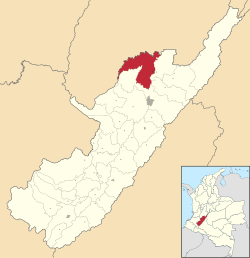
 Location of the municipality and town of Aipe in the Huila Department of Colombia | |
| Coordinates: 3°13′N 75°14′W / 3.217°N 75.233°W | |
| Country | |
| Department | Huila Department |
| Subregion | Subnorte |
| Founded | 2 January 1741 |
| Founded by | Teresa & Enrique Cortés |
| Government | |
| • Mayor | José Sevel Castro Tovar (2016-2019) |
| Area | |
| • Municipality and town | 801.04 km2 (309.28 sq mi) |
| Elevation | 350 m (1,150 ft) |
| Population (2015) | |
| • Municipality and town | 26,219 |
| • Density | 33/km2 (85/sq mi) |
| • Urban | 16,530 |
| Time zone | UTC-5 (Colombia Standard Time) |
| Website | Official website |
Aipe is a town and municipality in the Huila Department, Colombia. It is located on the west bank of the Magdalena River in the Central Ranges of the Colombian Andes at altitudes between 350 and 2,300 metres (1,150 and 7,550 ft). Aipe borders Natagaima, Ataco and Planadas of the department of Tolima in the north and west, Villavieja and Tello in the east, and the departmental capital Neiva in the south.[1]
- ^ (in Spanish) Official website Aipe
