| Aisne | |
|---|---|
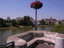
 The Aisne near the village of Soupir | |
 | |
| Location | |
| Country | France |
| Physical characteristics | |
| Source | |
| • location | Champagne-Ardenne |
| • coordinates | 48°56′44″N 05°10′46″E / 48.94556°N 5.17944°E |
| Mouth | |
• location | Oise |
• coordinates | 49°26′1″N 2°50′49″E / 49.43361°N 2.84694°E |
| Length | 356 km (221 mi) |
| Basin size | 7,752 km2 (2,993 sq mi) |
| Discharge | |
| • average | 63 m3/s (2,200 cu ft/s) |
| Basin features | |
| Progression | Oise→ Seine→ English Channel |
| Tributaries | |
| • left | Ruisseau de l'Étang Neuf, Boue, Ante, Auve, Tourbe, Dormoise, Rémy Galère, Ruisseau des Sugnons, Ruisseau de l'Indre |
| • right | Orne, Coubreuil, Sougniat, Biesme, Ruisseau du Fossé des Corbeaux, Aire, Ruisseau du Moulin, Ruisseau de Saint-Gourgon, Ruisseau des Ouvions, Ruisseau des Quatorze, Migny, Vaux, Ruisseau de Saint-Fergeux, Miette, Tordoir |
 | |


The Aisne (/eɪn/ ayn,[1] US also /ɛn/ en,[2] French: [ɛːn] ) is a river in northeastern France. It is a left tributary of the Oise. It gave its name to the French department of Aisne. It was known in the Roman period as Axona.
The river rises in the forest of Argonne, at Rembercourt-Sommaisne, near Sainte-Menehould. It flows north and then west before joining the Oise near Compiègne. The Aisne is 356 kilometres (221 mi) long.[3] Its main tributaries are the Vesle, the Aire and the Suippe. The Battle of the Axona was fought between the Romans and the Belgae near the Aisne in 57 BC. Three Battles of the Aisne were fought in the Aisne valley during the First World War.
- ^ "Aisne". The American Heritage Dictionary of the English Language (5th ed.). HarperCollins. Retrieved 18 July 2019.
- ^ "Aisne". Collins English Dictionary. HarperCollins. Retrieved 18 July 2019.
- ^ Sandre. "Fiche cours d'eau (H1--0200)".