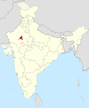
Ajmer State | |||||||||
|---|---|---|---|---|---|---|---|---|---|
Former State 1950–1956 | |||||||||
 Location of Ajmer State in India | |||||||||
| Country | |||||||||
| Region | North India | ||||||||
| Formation | 26 January 1950 | ||||||||
| Consolidation | 1 November 1956 (into Rajasthan) | ||||||||
| Dissolution | 1 November 1956 (by States Reorganisation Act, 1956) | ||||||||
| Capital and largest city | Ajmer | ||||||||
| Government | |||||||||
| • Chief minister | |||||||||
• 24 March 1952 – 31 October 1956 | Haribhau Upadhyaya (First and Last) | ||||||||
| Area | |||||||||
| • Total | 7,021 km2 (2,711 sq mi) | ||||||||
| Population | |||||||||
| • Total | 460,722 | ||||||||
| Time zone | UTC+05:30 (IST) | ||||||||
| |||||||||
Ajmer State was a separate state within India from 1950 to 1956 with Ajmer as its capital.[1] Ajmer State was formed in 1950 out of the territory of former province of Ajmer-Merwara, which became a province of the Indian Union on 15 August 1947. It formed an enclave within the state of Rajasthan. Following the States Reorganisation Act in 1956 it was merged with Rajasthan.[2]
- ^ Cite error: The named reference
awas invoked but never defined (see the help page). - ^ "States Reorganisation Act, 1956". India Code Updated Acts. Ministry of Law and Justice, Government of India. 31 August 1956. pp. section 9. Retrieved 16 May 2013.