| Akeld | |
|---|---|
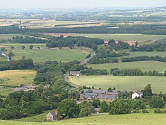
 View over Akeld from the south | |
Location within Northumberland | |
| Population | 221 (2011 census (including Kirknewton)) |
| OS grid reference | NT955295 |
| Unitary authority | |
| Ceremonial county | |
| Region | |
| Country | England |
| Sovereign state | United Kingdom |
| Post town | WOOLER |
| Postcode district | NE71 |
| Dialling code | 01668 |
| Police | Northumbria |
| Fire | Northumberland |
| Ambulance | North East |
| UK Parliament | |
Akeld is a village and civil parish in Northumberland, England. It is situated around 2.7 miles (4.3 km) to the west of Wooler and 9.3 miles (15.0 km) from the border with Scotland at Coldstream. The village lies on the northern limit of Northumberland National Park and on the foot of the Cheviot Hills massif. It is overlooked by Akeld Hill and Harehope Hill to the south. In 2001 Akeld had a population of 82,[1] increasing at the 2011 Census to 221, although this was partly due to the parish merging with that of Kirknewton.[2] The burn which runs through the village and down to the Milfield Basin also bears the name Akeld.
The economy of Akeld has historically been focussed on agriculture. The position of the village between the English and Scottish borders has meant it often suffered at the hand of border raids. In the 19th century, Akeld was served by a railway station which made the village less isolated. The closure of the railway in the 20th century, combined with declining agricultural employment, has led to a reduction in the village's size and population.
- ^ "Census 2001". Archived from the original on 13 June 2011. Retrieved 31 January 2009.
- ^ "Parish population 2011". Retrieved 3 July 2015.
