| Akush | |
|---|---|
| Акуш / Ақыш | |
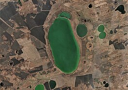
 Sentinel-2 image of the lake | |
| Location | Ishim Plain West Siberian Plain |
| Coordinates | 55°19′28″N 68°57′47″E / 55.32444°N 68.96306°E |
| Type | endorheic |
| Primary outflows | none |
| Basin countries | Kazakhstan |
| Max. length | 8.6 kilometers (5.3 mi) |
| Max. width | 3.8 kilometers (2.4 mi) |
| Surface area | 25.8 square kilometers (10.0 sq mi) |
| Average depth | 3 meters (9.8 ft) |
| Max. depth | 4 meters (13 ft) |
| Residence time | UTC+6 |
| Shore length1 | 20.9 kilometers (13.0 mi) |
| Surface elevation | 120 meters (390 ft) |
| 1 Shore length is not a well-defined measure. | |
Akush (Russian: Акуш) or Akysh (Kazakh: Ақыш , is a salt lake in Kyzylzhar District, North Kazakhstan Region, Kazakhstan and Kazan District, Tyumen Oblast, Russian Federation.[1]
The lake is located 35 kilometers (22 mi) to the SSW of Kazanskoye, the district capital in Russia, and 43 kilometers (27 mi) to the NNW of Petropavl city, the regional capital in Kazakhstan. Dubrovnoye village lies 3 kilometers (1.9 mi) to the southwest of the southern end. Lake Akush is located at the Kazakhstan–Russia border, that cuts across the lake in the middle and bends northwards along the eastern shore.[2][3]

