al-Masmiyya al-Kabira
المسمية الكبيرة al-Masmiyya | |
|---|---|
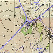
 Masmiya al Kabira, 1947 | |
| Etymology: from "to be lofty"[1] | |
A series of historical maps of the area around Al-Masmiyya al-Kabira (click the buttons) | |
Location within Mandatory Palestine | |
| Coordinates: 31°45′27″N 34°47′05″E / 31.75750°N 34.78472°E | |
| Palestine grid | 129/129 |
| Geopolitical entity | Mandatory Palestine |
| Subdistrict | Gaza |
| Date of depopulation | July 8, 1948[4] |
| Area | |
| • Total | 20,687 dunams (20.687 km2 or 7.987 sq mi) |
| Population (1945) | |
| • Total | 2,520[2][3] |
| Cause(s) of depopulation | Military assault by Yishuv forces |
| Current Localities | Bnei Re'em,[5] Hatzav,[5] Yinon,[5] Ahva[5] |
Al-Masmiyya al-Kabira (Arabic: المسمية الكبيرة) was a Palestinian village in the Gaza Subdistrict, located 41 kilometers (25 mi) northeast of Gaza.[6] With a land area of 20,687 dunams, the village site (135 dunams) was situated on an elevation of 75 meters (246 ft) along the coastal plain. It was depopulated during the 1948 Arab–Israeli War. Before the war, it had a population of 2,520 in 1945.[5]
The name of the village has been retained in the "Masmiya junction", the unofficial name of the large junction connecting Israel's Highway 3 with Highway 40, which the village ruins are adjacent to.
- ^ Palmer, 1881, p. 272
- ^ Government of Palestine, Department of Statistics, 1945, p. 32
- ^ a b Government of Palestine, Department of Statistics. Village Statistics, April, 1945. Quoted in Hadawi, 1970, p. 46
- ^ Morris, 2004, p. xvii village #273, also gives depopulation method
- ^ a b c d e Khalidi, 1992, p.125.
- ^ Khalidi, 1992, p.124


