This article may need to be rewritten to comply with Wikipedia's quality standards. (October 2023) |
This article needs to be updated. (October 2023) |
Al-Tanf
التَّنْف | |
|---|---|
 5th SFG (A) operators in a landing zone at Al-Tanf, November 2017 | |
| Nickname: 55 KM area | |
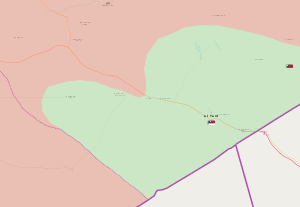
 The "55 kilometer area": Location of the base in southeastern Syria and its surrounding "deconfliction zone" | |
| Coordinates: 33°30′21″N 38°37′04″E / 33.50583°N 38.61778°E | |
| Country | |
| Governorate | Homs |
| Occupation | |
| District | Tadmur |
| Subdistrict | Al-Sabe' Biyar |
| Region | Al-Tanf Pocket (جيب التنف) |
| Established | 3 March 2016[1] |
| Government | |
| • Rebel commander | Muthanna Tala[2] (MaT) |
| Time zone | UTC+2 (EET) |
| • Summer (DST) | UTC+3 (EEST) |
 | |
Al-Tanf (Arabic: التَّنْف) is a U.S. military base in an American occupied part of the Homs Governorate, Syria. It is located 24km (15 mi) west of the al-Walid border crossing in the Syrian Desert. The surrounding deconfliction zone is located along the Iraq–Syria border and the Jordan–Syria border. The garrison is located along a critical road known as the M2 Baghdad–Damascus Highway. The Rukban refugee camp for internally displaced Syrians is located within the deconfliction zone.
A significant United States Armed Forces presence at the outpost began in early 2016 during the American-led intervention in the Syrian civil war in order to train anti-Islamic State fighters of the New Syrian Army armed opposition group, which was dissolved and reemerged as the Revolutionary Commando Army (Maghawir al-Thawra) in December 2016. As of 2024, the Al-Tanf base continues to serve as the headquarters for the Revolutionary Commando Army and a contingent of at least 200 U.S. soldiers operating on behalf of the CJTF-OIR Coalition.
- ^ "New Syrian Army will 'liberate eastern Syria' from IS". The New Arab. 11 March 2016. Retrieved 22 October 2017.
- ^ Muhammad Ersan (1 June 2017). "Syrian rebel commander: 150 US troops at al-Tanf base". Al-Monitor. Archived from the original on 12 June 2017.

