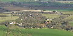
| Alciston | |
|---|---|
 Alciston from Bostal Hill | |
Location within East Sussex | |
| Area | 7.0 km2 (2.7 sq mi) [1] |
| Population | 146 (2007-Parish)[1] |
| • Density | 44/sq mi (17/km2) |
| OS grid reference | TQ506055 |
| • London | 48 miles (77 km) NNW |
| District | |
| Shire county | |
| Region | |
| Country | England |
| Sovereign state | United Kingdom |
| Post town | POLEGATE |
| Postcode district | BN26 |
| Dialling code | 01323 |
| Police | Sussex |
| Fire | East Sussex |
| Ambulance | South East Coast |
| UK Parliament | |
Alciston is a village and civil parish in the Wealden district of East Sussex, England. It is inland, just off the A27 road, about ten miles (16 km) north-west of Eastbourne and seven miles (11 km) east of Lewes. The ecclesiastical parish is linked with that of Selmeston and Berwick.

Saxon in origin, its name was then Aelfsige; it is mentioned in the Domesday Book of 1086. The present 14th-century church, of unknown dedication, is built of chalk from the nearby South Downs.[2] There is a large medieval tithe barn in the village. It is 170 feet (52 m) long and is the largest in Sussex. There is also the ruins of a square shaped dovecote built by monks in C14, who used Alciscton as a grange of Battle Abbey.
Every Good Friday, the road outside the Rose Cottage Inn is closed for the villagers to take part in a traditional skipping contest.[3]
The historian C.V. Wedgwood is buried in the church graveyard.

- ^ a b "East Sussex in Figures". East Sussex County Council. Retrieved 26 April 2008.
- ^ "Alciston Parish Church". Sacred Sussex. Diocese of Chichester. Archived from the original on 8 February 2009. Retrieved 20 April 2008.
- ^ Geograph
