Alderwood | |
|---|---|
Neighbourhood | |
 View of Alderwood from Horner Avenue and Beta Street | |
| Coordinates: 43°36′27″N 79°32′25″W / 43.60750°N 79.54028°W | |
| Country | Canada |
| Province | Ontario |
| City | Toronto |
| Established | 1850 Etobicoke Township |
| Developed | 1918 (Subdivision) 'New Toronto Park' |
| Established as Postal Village | 1933 |
| Changed Municipality | 1998 Toronto from Etobicoke |
| Government | |
| • MP | James Maloney (Etobicoke—Lakeshore) |
| • MPP | Christine Hogarth (Etobicoke—Lakeshore) |
| • Councillor | Mark Grimes (Ward 3 Etobicoke—Lakeshore) |
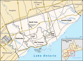
Alderwood is a neighbourhood in the city of Toronto, Ontario, Canada. It is in the western section of Toronto, within the district of Etobicoke. It is bounded by the Etobicoke Creek to the west, the Gardiner Expressway to the north, the CPR railway to the east and the CNR railway to the south.
Alderwood is named after Etobicoke, the municipality of which it originally was a part, which is a native word meaning "place where the alder trees grow."
