| Alfords Point Sydney, New South Wales | |||||||||||||||
|---|---|---|---|---|---|---|---|---|---|---|---|---|---|---|---|
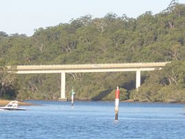
 Alfords Point Bridge over Georges River | |||||||||||||||
 | |||||||||||||||
| Population | 3,131 (2021 census)[1] | ||||||||||||||
| Postcode(s) | 2234 | ||||||||||||||
| Elevation | 98 m (322 ft) | ||||||||||||||
| Location | 28 km (17 mi) SW of Sydney CBD | ||||||||||||||
| LGA(s) | Sutherland Shire | ||||||||||||||
| State electorate(s) | Miranda | ||||||||||||||
| Federal division(s) | Hughes | ||||||||||||||
| |||||||||||||||
Alfords Point is a suburb in southern Sydney, in the state of New South Wales, Australia. Alfords Point is 28 kilometres south of the Sydney central business district, within the local government area of the Sutherland Shire. Alfords Point shares the postcode of 2234 with neighbouring suburbs of Menai, Bangor and Illawong.
Alfords Point is on the southern bank of the Georges River. The suburb is nearly completely surrounded by bushland from the Georges River nature Reserve and with Alfords Point Road within its eastern border running south to north onto the Alfords Point Road Bridge across the Georges River towards Padstow. Brushwood Drive is the only road to enter and exit Alfords Point.
- ^ Australian Bureau of Statistics (28 June 2022). "Alfords Point (State Suburb)". 2021 Census QuickStats. Retrieved 2 August 2024.