Alirajpur district | |
|---|---|
 Traditional Bhil fair in Alirajpur | |
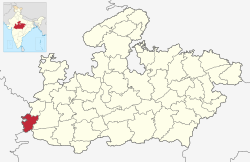
 Location of Alirajpur district in Madhya Pradesh | |
| Coordinates (Alirajpur): 22°18′18″N 74°21′36″E / 22.30500°N 74.36000°E | |
| Country | India |
| State | Madhya Pradesh |
| Division | Indore |
| Headquarters | Alirajpur |
| Government | |
| • District Magistrate | Shri Raghvendra Singh |
| • Lok Sabha constituencies | Ratlam |
| • Vidhan Sabha constituencies | 1. Alirajpur, 2. Jobat |
| Area | |
• Total | 3,182 km2 (1,229 sq mi) |
| Population (2011) | |
• Total | 728,677 |
| • Density | 230/km2 (590/sq mi) |
| Demographics | |
| • Literacy | 37.22 per cent |
| • Sex ratio | 1009 |
| Time zone | UTC+05:30 (IST) |
| Website | alirajpur |
Alirajpur is one of the 55 districts of Madhya Pradesh state in India. It was created from Alirajpur, Jobat and Bhabra tehsils of the former Jhabua district on 17 May 2008. It is the least literate district in India as per Census 2011. Alirajpur is the administrative headquarters of the district. The district occupies an area of 2,165.24 square kilometres (836.00 sq mi), and at the 2011 census had a population of 728,999. It includes the city of Alirajpur.