| Alkali Lake | |
|---|---|
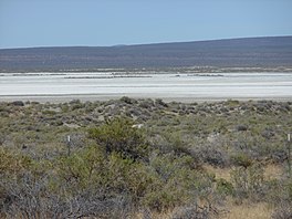
 Alkali Lake dry lakebed and surrounding desert | |
| Location | Lake County, Oregon |
| Coordinates | 42°58′38″N 120°01′41″W / 42.97722°N 120.02806°W |
| Lake type | seasonal, alkali |
| Basin countries | United States |
| Surface elevation | 4,332 ft (1,320 m) |
Alkali Lake is a geographic sink located in Lake County, Oregon, United States. It lies within the Alkali Subbasin of the Summer Lake Basin watershed in southeastern Oregon.[1] The lake is situated 26 miles east of Christmas Valley, Oregon, northeast of Lake Abert,[2] and directly west of Abert Rim and Highway 395.
Alkali Lake is believed to have reached a prehistoric maximum depth of 270.7 feet (82.5 meters) and covered about 1,448.4 square miles (3,751 square kilometers). Since then, its water level has fluctuated, with a general trend towards drying.[1] Notable features include dissolved alkaline salts averaging 10% of total brine weight in its seasonal waters[2] and a nearby chemical disaster, Alkali Lake Chemical Waste Dump.
